
High pressure ridging dominates the western US and southwest Canada mainly by mid and late next week as the eastern US gets a turn at unsettled weather (24th of October onward for about a week). It is looking like some seriously cold air and unusual pre-Halloween snowfalls are possible in many areas of the eastern US, with snow possible even to northern Georgia and Mississippi! Around or just after Halloween, expect a shift back to unsettled for the western US, with more snow and probably colder than usual weather, early season additional accumulations for the Northwest US and Bogus basin also. Early November looks busy with storms and snow all across the western US and southwest Canada.


Expect a colder and more snowy winter for Revelstoke, Kingfisher Heli, Bogus Basin, and Aspen this season! I am thinking early openings possible again on some great early season conditions for all areas mentioned. We are in a neutral ENSO pattern (no El Nino or La Nina), leaning to La Nina this winter 2019-2020. Meteorologist/ Chris Manly


45 to 90cm of snow (18" to 36") is possible in the next 16 days for areas 1,200 to 1,500+ meters in elevation (4,000 to 5,000 feet), which includes many resorts base to top!
 *An El Nino is still favored according to the above Climate Prediction Center chart*
 *We have seen some areas of cooling in the Nino 1+2 and 3 regions, as this El Nino struggles to form. This is indicating cooling in the subsurface waters, which is a factor that is looked at for potential SST's*
 *As of Sep 12, there is some warming going on again in the referenced "Nino 3" region, so overall there is a positive SST anomaly, but mostly less than +.5 (in yellow on the above chart), which is the threshold that needs to be met for 3 consecutive months before an actual El Nino pattern is recognized. For now we are in an "ENSO neutral" status.


HEAT: https://www.washingtonpost.com/news/capital-weather-gang/wp/2018/07/17/scorching-scandinavia-record-breaking-heat-hits-norway-finland-and-sweden (90+ degrees in Norway, all time record high temps!)
Great resource for current SST’s and anomalies:
https://www.tropicaltidbits.com/analysis/ocean/
International Research Institute:
https://iri.columbia.edu/our-expertise/climate/forecasts/enso/current/?enso_tab=enso-cpc_plume
Latest ENSO Discussion:
http://www.cpc.ncep.noaa.gov/products/analysis_monitoring/enso_advisory/ensodisc.php
Space Weather ("Solar Minimum"):
https://www.swpc.noaa.gov/products/solar-cycle-progression
NCEP model forecast SST anomalies (1 model forecasting La Nina):
http://www.cpc.ncep.noaa.gov/products/NMME/current/tmpsfc_Seas2.html
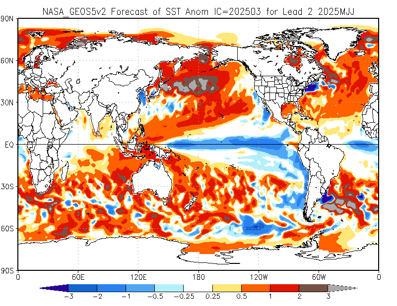
The ONE outlier model forecasting La Nina:
http://www.cpc.ncep.noaa.gov/products/NMME/current/images/NASA_GEOS5v2_ensemble_tmpsfc_season2.png
Loads of the latest SST charts from ESRL, knock yourself out:
https://www.esrl.noaa.gov/psd/map/clim/sst.shtml
Best anomaly chart (in my opinion):
https://www.esrl.noaa.gov/psd/map/images/sst/sst.anom.hov.gif
Detailed ENSO Discussion from NOAA:
http://www.cpc.ncep.noaa.gov/products/analysis_monitoring/lanina/enso_evolution-status-fcsts-web.pdf
More info/ charts on Modoki El Nino:
http://www.jamstec.go.jp/frcgc/research/d1/iod/enmodoki_home_s.html.en
El Nino/ La Nina years/ ONI:
http://ggweather.com/enso/oni.htm
A GREAT resource for "no BS" historical ski season info:
http://bestsnow.net/
Latest PDO and history:
http://research.jisao.washington.edu/pdo/PDO.latest.txt
HEAT: https://www.washingtonpost.com/news/capital-weather-gang/wp/2018/07/17/scorching-scandinavia-record-breaking-heat-hits-norway-finland-and-sweden (90+ degrees in Norway, all time record high temps!)
Great resource for current SST’s and anomalies:
https://www.tropicaltidbits.com/analysis/ocean/
International Research Institute:
https://iri.columbia.edu/our-expertise/climate/forecasts/enso/current/?enso_tab=enso-cpc_plume
Latest ENSO Discussion:
http://www.cpc.ncep.noaa.gov/products/analysis_monitoring/enso_advisory/ensodisc.php
Space Weather ("Solar Minimum"):
https://www.swpc.noaa.gov/products/solar-cycle-progression
NCEP model forecast SST anomalies (1 model forecasting La Nina):
http://www.cpc.ncep.noaa.gov/products/NMME/current/tmpsfc_Seas2.html
The ONE outlier model forecasting La Nina:
http://www.cpc.ncep.noaa.gov/products/NMME/current/images/NASA_GEOS5v2_ensemble_tmpsfc_season2.png
Loads of the latest SST charts from ESRL, knock yourself out:
https://www.esrl.noaa.gov/psd/map/clim/sst.shtml
Best anomaly chart (in my opinion):
https://www.esrl.noaa.gov/psd/map/images/sst/sst.anom.hov.gif
Detailed ENSO Discussion from NOAA:
http://www.cpc.ncep.noaa.gov/products/analysis_monitoring/lanina/enso_evolution-status-fcsts-web.pdf
More info/ charts on Modoki El Nino:
http://www.jamstec.go.jp/frcgc/research/d1/iod/enmodoki_home_s.html.en
El Nino/ La Nina years/ ONI:
http://ggweather.com/enso/oni.htm
A GREAT resource for "no BS" historical ski season info:
http://bestsnow.net/
Latest PDO and history:
http://research.jisao.washington.edu/pdo/PDO.latest.txt


 40°
31°
40°
31°

49°
34°
26°
22°

 48°
26°
48°
26°


