 Mad River Mo... Nitehawk Ski...
  Clear Fork R... Snow Trails
 Breckenridge Ski Resort
  Granby-Grand County Airport, CO Updated May 05 @ 05:13

 Southeast
 WebCams
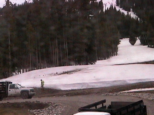
Top of Quicksilver Super6 - Elevation: 10,460' / 3,188m
Base of Peak 8 - Elevation: 9,950' / 3,034m

Top of Springmeier - 11,059 feet elevation
High Alpine Bowls - 12,141 feet elevation
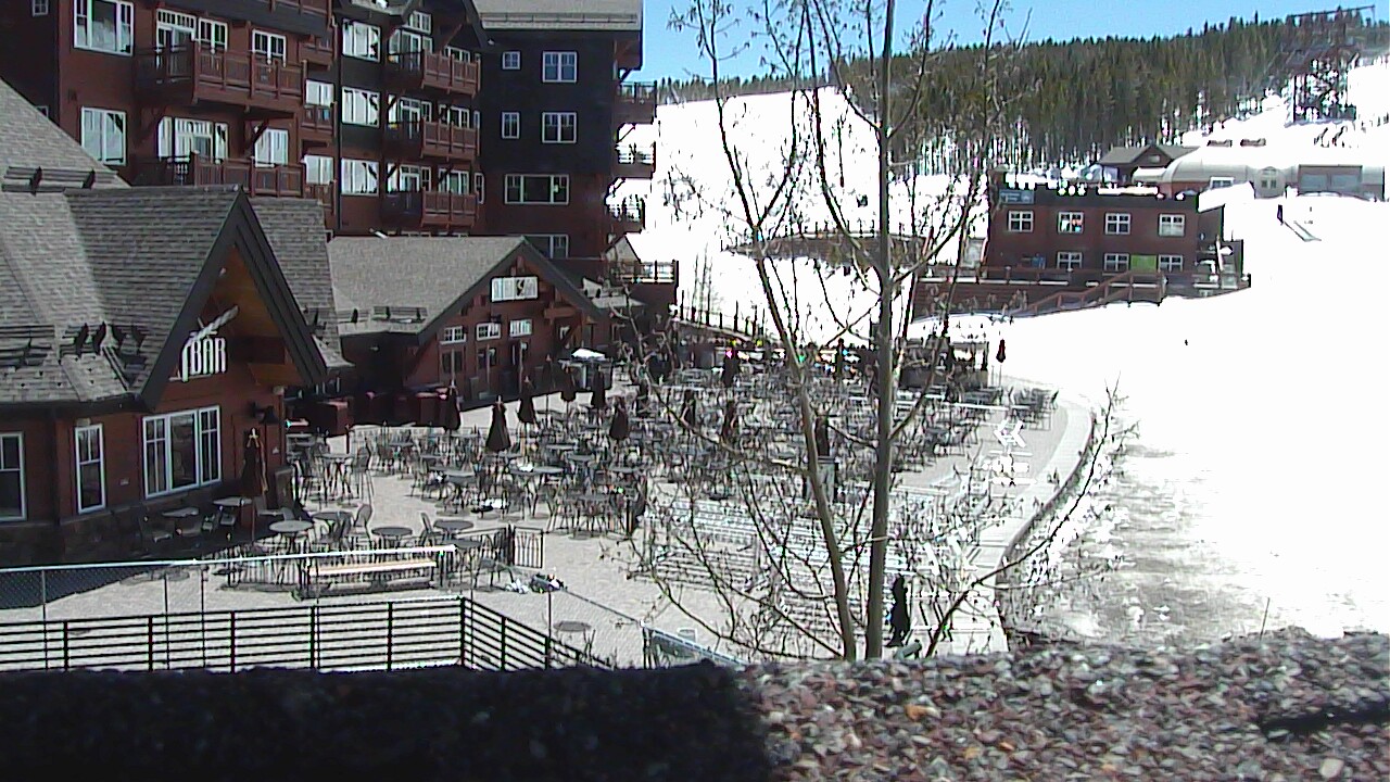
Ski Hill Grill (Base of Peak 8) - Elevation: 9,950' / 3,034m
SUNDAY
May 5

43° / 15°

22 - 33
mph
 7
7
MONDAY
May 6
21° / 19°

34 - 45
mph
6
TUESDAY
May 7

20° / 8°

10 - 19
mph
8
WEDNESDAY
May 8
25° / 18°

6 - 14
mph
1
THURSDAY
May 9
28° / 20°
8 - 16
mph
3
FRIDAY
May 10
33° / 24°
8 - 16
mph
10
SATURDAY
May 11
36° / 30°

3 - 11
mph
2
Mostly cloudy becoming partly cloudy at times continuing through overnight, with periods of snow expected overnight.
Heavy snow overnight. Snowfall is forecast to be 4 to 7 overnight.
Potential Precip:
0.13 to 0.64
Hi: 51°Low: 21°
6,988 feet to 13500 feet
Winds S at 15 to 26 mph with gusts to 35 in the morning, becoming S at 10 to 19 mph with gusts to 29 in the afternoon, and then variable at 16 to 27 mph with gusts to 51 overnight.
Mostly cloudy becoming partly cloudy at times continuing through overnight, with periods of snow expected overnight.
Heavy snow overnight. Snowfall is forecast to be 8 to 12 overnight.
Potential Precip:
0.13 to 0.64
Hi: 32°Low: 6°
6,988 feet to 13500 feet
Winds SW at 36 to 47 mph in the morning, becoming S at 46 to 57 mph with gusts to 71 in the afternoon, and then variable at 49 to 60 mph with gusts to 79 overnight.
Partly cloudy becoming mostly cloudy at times continuing through overnight, with periods of snow expected at any time.
Moderate snow during the day, becoming light in the evening and moderate overnight. Snowfall is forecast to be 1 to 2 during the day, and 3 to 5 inches in the evening and overnight.
Potential Precip:
0.14 to 0.68
Hi: 30°Low: 25°
7,924 feet to 9474 feet
Winds W at 24 to 35 mph with gusts to 51 in the morning, becoming W at 15 to 26 mph with gusts to 41 in the afternoon, and then W at 14 to 23 mph with gusts to 44 overnight.
Partly cloudy becoming mostly cloudy at times continuing through overnight, with periods of snow expected at any time.
Moderate snow with periods of heavy during the day, becoming light in the evening and heavy overnight. Snowfall is forecast to be 2 to 4 during the day, and 6 to 9 inches in the evening and overnight.
Potential Precip:
0.14 to 0.68
Hi: 12°Low: 9°
7,924 feet to 9474 feet
Winds W at 59 to 70 mph in the morning, becoming W at 51 to 62 mph in the afternoon, and then W at 43 to 54 mph with gusts to 71 overnight.
Mostly cloudy becoming partly cloudy at times continuing through overnight, with periods of snow expected at any time.
Heavy snow during the day, becoming light with periods of moderate in the evening through overnight. Snowfall is forecast to be 4 to 7 during the day, and 1 to 2 inches in the evening and overnight.
Potential Precip:
0.14 to 0.7
Hi: 28°Low: 9°
3,303 feet to 8982 feet
Winds W at 15 to 26 mph with gusts to 47 in the morning, becoming variable at 5 to 13 mph in the afternoon, and then W at 7 to 15 mph overnight.
Mostly cloudy becoming partly cloudy at times continuing through overnight, with periods of snow expected at any time.
Heavy snow during the day, becoming moderate with periods of heavy in the evening through overnight. Snowfall is forecast to be 8 to 11 during the day, and 2 to 4 inches in the evening and overnight.
Potential Precip:
0.14 to 0.7
Hi: 10°Low: 0°
3,303 feet to 8982 feet
Winds W at 42 to 53 mph with gusts to 62 in the morning, becoming W at 26 to 37 mph with gusts to 43 in the afternoon, and then W at 27 to 38 mph with gusts to 63 overnight.
Mostly cloudy through the day and overnight, with periods of snow expected in the morning through overnight.
Periods of light snow throughout the day and overnight. Snowfall is forecast to be 1 to 2 inches.
Potential Precip:
0.02 to 0.09
Hi: 33°Low: 18°
5,760 feet to 10239 feet
Winds NW at 6 to 14 mph in the morning, becoming variable at 5 to 12 mph in the afternoon through overnight.
Mostly cloudy through the day and overnight, with periods of snow expected in the morning through overnight.
Periods of light snow throughout the day and overnight. Snowfall is forecast to be 1 to 2 inches.
Potential Precip:
0.02 to 0.09
Hi: 15°Low: 11°
5,760 feet to 10239 feet
Winds W at 10 to 18 mph in the morning, becoming NW at 12 to 21 mph in the afternoon, and then variable at 4 to 12 mph overnight.
Cloudy becoming partly cloudy in the late morning continuing through overnight. Periods of snow are expected at any time.
Periods of moderate snow throughout the day, light at times overnight. Snowfall is forecast to be 2 to 4 inches.
Potential Precip:
0.08 to 0.4
Hi: 36°Low: 21°
6,737 feet to 10790 feet
Winds variable at 5 to 13 mph throughout the day and into overnight.
Cloudy becoming partly cloudy in the late morning continuing through overnight. Periods of snow are expected at any time.
Periods of moderate to heavy snow throughout the day, light at times overnight. Snowfall is forecast to be 3 to 6 inches.
Potential Precip:
0.08 to 0.4
Hi: 18°Low: 15°
6,737 feet to 10790 feet
Winds SE at 12 to 21 mph through the day, becoming S at 11 to 20 mph overnight.
Cloudy becoming partly cloudy in the evening continuing through overnight, with periods of rain and snow expected overnight.
Periods of moderate to heavy snow throughout the day, light at times overnight. Snowfall is forecast to be 4 to 7 inches.
Potential Precip:
0.31 to 1.53
Hi: 40°Low: 26°
8,242 feet to 11608 feet
Winds variable at 5 to 13 mph through the day, becoming variable at 4 to 12 mph overnight.
Cloudy becoming partly cloudy in the evening continuing through overnight, with periods of snow expected at any time.
Periods of heavy snow throughout the day, moderate at times overnight. Snowfall is forecast to be 13 to 17 inches.
Potential Precip:
0.31 to 1.53
Hi: 22°Low: 19°
8,242 feet to 11608 feet
Winds SE at 13 to 22 mph through the day, becoming SW at 13 to 22 mph with gusts to 29 overnight.
Mostly cloudy becoming cloudy at times continuing through overnight, with periods of rain and snow expected overnight.
Periods of light to moderate snow throughout the day. Snowfall is forecast to be 1 to 2 inches.
Potential Precip:
0.14 to 0.7
Hi: 43°Low: 31°
10,165 feet to 12811 feet
Winds variable at 4 to 11 mph through the day, becoming variable at 5 to 12 mph overnight.
Mostly cloudy becoming cloudy at times continuing through overnight, with periods of snow expected at any time.
Periods of moderate to heavy snow throughout the day, moderate at times overnight. Snowfall is forecast to be 5 to 8 inches.
Potential Precip:
0.14 to 0.7
Hi: 25°Low: 24°
10,165 feet to 12811 feet
Winds variable at 7 to 15 mph through the day, becoming SW at 9 to 17 mph with gusts to 28 overnight.
 Sunrise & Sunset

Lunar Calendar


advertisement

 Snow Maps and Weather Stations in the Area
 ![]() 15in, past 7 days. Snow surface is machine groomed and packed powder
15in, past 7 days. Snow surface is machine groomed and packed powder
Snow report provided by SnoCountry
Plan your future trip using our temperature, snowfall, snow depth, and precipitation tool
 Day |
 High Temperatures |
 Low Temperatures |
 Precipitation |
 Snowfall |
 Snow Depth |
||||||||||||||
|---|---|---|---|---|---|---|---|---|---|---|---|---|---|---|---|---|---|---|---|
| Avg | High | Year | Low | Year | Avg | High | Year | Low | Year | Avg | Max | Year | Avg | Max | Year | Avg | Max | Year | |
| 1 | 46 | 64 | 1901 | 28 | 1898 | 18 | 33 | 1905 | 0 | 1893 | 0.063 | 0.89 | 1973 | 0.74 | 13.0 | 1973 | 2.8 | 24 | 1957 |
| 2 | 46 | 61 | 1897 | 22 | 1899 | 20 | 31 | 1904 | 10 | 1903 | 0.054 | 0.90 | 1904 | 0.70 | 11.1 | 2013 | 2.8 | 31 | 2008 |
| 3 | 46 | 66 | 1908 | 23 | 1899 | 19 | 31 | 1902 | 3 | 1907 | 0.058 | 1.40 | 1904 | 0.56 | 14.0 | 1904 | 2.5 | 30 | 2008 |
| 4 | 48 | 64 | 1896 | 32 | 1898 | 23 | 38 | 1896 | 4 | 1899 | 0.033 | 0.41 | 1984 | 0.40 | 6.9 | 1984 | 1.7 | 28 | 2008 |
| 5 | 47 | 64 | 1896 | 30 | 1898 | 22 | 46 | 1896 | -2 | 1903 | 0.049 | 0.50 | 1969 | 0.66 | 6.5 | 2001 | 1.3 | 27 | 2008 |
| 6 | 50 | 65 | 1911 | 32 | 1899 | 21 | 36 | 1894 | 9 | 1978 | 0.086 | 1.50 | 1978 | 0.90 | 16.0 | 1978 | 1.2 | 24 | 2008 |
| 7 | 53 | 68 | 1894 | 32 | 1893 | 21 | 38 | 1896 | 5 | 1908 | 0.066 | 1.23 | 1969 | 0.52 | 7.5 | 1961 | 0.9 | 20 | 2008 |
| 8 | 53 | 65 | 1895 | 39 | 1899 | 22 | 29 | 1902 | 4 | 1978 | 0.045 | 0.46 | 1995 | 0.32 | 6.0 | 1995 | 0.5 | 19 | 2008 |
| 9 | 55 | 65 | 1910 | 43 | 1903 | 23 | 31 | 1913 | 14 | 1909 | 0.067 | 0.75 | 2013 | 0.49 | 4.5 | 1957 | 0.5 | 15 | 2008 |
| 10 | 54 | 66 | 1913 | 37 | 1912 | 23 | 31 | 1910 | 13 | 1895 | 0.073 | 0.92 | 1955 | 0.60 | 11.6 | 1955 | 0.5 | 12 | 2008 |
| 11 | 53 | 70 | 1913 | 40 | 1896 | 23 | 35 | 1909 | 5 | 1895 | 0.048 | 0.62 | 1982 | 0.40 | 6.0 | 1982 | 0.4 | 8 | 2008 |
| 12 | 54 | 70 | 1913 | 36 | 1896 | 23 | 31 | 1907 | 7 | 1895 | 0.040 | 0.73 | 2014 | 0.31 | 8.4 | 2014 | 0.4 | 9 | 2014 |
| 13 | 53 | 66 | 1978 | 32 | 1896 | 25 | 34 | 1911 | 12 | 1895 | 0.060 | 0.80 | 1896 | 0.58 | 8.0 | 2008 | 0.6 | 12 | 1982 |
| 14 | 53 | 70 | 1894 | 31 | 1907 | 24 | 45 | 1899 | 9 | 1896 | 0.049 | 0.77 | 1958 | 0.48 | 6.5 | 1980 | 0.4 | 8 | 2010 |
| 15 | 56 | 69 | 1978 | 30 | 1896 | 25 | 37 | 1978 | 11 | 1909 | 0.062 | 1.52 | 1980 | 0.43 | 8.4 | 1957 | 0.4 | 8 | 1957 |
| 16 | 56 | 72 | 1978 | 25 | 1895 | 26 | 42 | 1978 | 14 | 1895 | 0.060 | 1.05 | 1991 | 0.45 | 9.5 | 1991 | 0.2 | 7 | 1957 |
| 17 | 55 | 71 | 1897 | 34 | 1895 | 24 | 33 | 1897 | -6 | 1895 | 0.035 | 0.85 | 1995 | 0.16 | 4.2 | 1983 | 0.1 | 4 | 1957 |
| 18 | 57 | 71 | 1913 | 34 | 1903 | 26 | 33 | 1905 | 7 | 1895 | 0.029 | 0.38 | 1993 | 0.08 | 2.5 | 1971 | 0.1 | 2 | 1971 |
| 19 | 55 | 67 | 1906 | 44 | 1903 | 25 | 39 | 1904 | 13 | 1895 | 0.063 | 0.92 | 2015 | 0.31 | 7.4 | 1983 | 0.1 | 5 | 1960 |
| 20 | 54 | 72 | 1894 | 36 | 1911 | 27 | 39 | 1904 | 16 | 1896 | 0.047 | 0.55 | 2011 | 0.28 | 6.1 | 1900 | 0.1 | 2 | 2011 |
| 21 | 52 | 68 | 1978 | 34 | 1910 | 26 | 35 | 1978 | 13 | 1911 | 0.035 | 0.62 | 1976 | 0.12 | 4.0 | 2001 | 0.0 | 1 | 1952 |
| 22 | 55 | 72 | 1978 | 34 | 1895 | 27 | 54 | 1896 | 16 | 1895 | 0.044 | 0.81 | 2009 | 0.19 | 5.0 | 1895 | 0.0 | T | 1952 |
| 23 | 57 | 78 | 1978 | 32 | 1895 | 27 | 46 | 1896 | 18 | 1895 | 0.060 | 0.66 | 1954 | 0.17 | 5.0 | 1906 | 0.0 | 0 | 2016 |
| 24 | 57 | 73 | 1896 | 40 | 1895 | 28 | 34 | 1977 | 15 | 1895 | 0.057 | 1.03 | 1908 | 0.13 | 6.0 | 2002 | 0.0 | 1 | 2007 |
| 25 | 57 | 71 | 1897 | 44 | 1907 | 29 | 49 | 1896 | 13 | 1895 | 0.076 | 1.06 | 1999 | 0.30 | 14.8 | 1950 | 0.3 | 15 | 1950 |
| 26 | 57 | 68 | 1902 | 46 | 1907 | 28 | 44 | 1896 | 18 | 1895 | 0.050 | 0.76 | 1996 | 0.10 | 2.0 | 1968 | 0.2 | 7 | 1950 |
| 27 | 58 | 70 | 1894 | 47 | 1908 | 29 | 44 | 1896 | 18 | 1893 | 0.059 | 0.72 | 1966 | 0.13 | 4.4 | 1893 | 0.1 | 3 | 1955 |
| 28 | 56 | 71 | 1896 | 41 | 1903 | 29 | 41 | 1897 | 21 | 1908 | 0.049 | 0.64 | 1953 | 0.13 | 5.5 | 1903 | 0.0 | 1 | 1975 |
| 29 | 59 | 70 | 1910 | 30 | 1895 | 29 | 44 | 1897 | 20 | 1911 | 0.062 | 1.80 | 1895 | 0.22 | 18.0 | 1895 | 0.0 | T | 2013 |
| 30 | 58 | 69 | 1912 | 29 | 1895 | 30 | 44 | 1896 | 11 | 1895 | 0.069 | 0.76 | 1997 | 0.27 | 7.5 | 1895 | 0.1 | 5 | 2004 |
| 31 | 59 | 74 | 1977 | 42 | 1909 | 28 | 38 | 1897 | 12 | 1895 | 0.064 | 0.84 | 2014 | 0.11 | 2.3 | 1894 | 0.0 | 1 | 2013 |
Day |
High Temperatures |
Low Temperatures |
Precipitation |
Snowfall |
Snow Depth |
||||||||||||||
|---|---|---|---|---|---|---|---|---|---|---|---|---|---|---|---|---|---|---|---|
| Avg | High | Year | Low | Year | Avg | High | Year | Low | Year | Avg | Max | Year | Avg | Max | Year | Avg | Max | Year | |
| 1 | 41 | 58 | 1992 | 19 | 1967 | 17 | 33 | 1959 | -8 | 1993 | 0.066 | 0.50 | 2006 | 0.95 | 8.1 | 1973 | 42.2 | 77 | 2011 |
| 2 | 42 | 59 | 1981 | 22 | 2008 | 18 | 33 | 1965 | -5 | 1993 | 0.076 | 0.93 | 1999 | 1.13 | 12.5 | 1999 | 41.8 | 77 | 2011 |
| 3 | 43 | 57 | 1985 | 24 | 2008 | 19 | 31 | 1985 | -6 | 1993 | 0.057 | 0.55 | 1984 | 0.77 | 7.8 | 1984 | 40.7 | 77 | 2011 |
| 4 | 45 | 56 | 2012 | 26 | 2001 | 21 | 36 | 1956 | 5 | 1973 | 0.044 | 0.37 | 2009 | 0.58 | 5.0 | 2009 | 39.1 | 74 | 2011 |
| 5 | 46 | 60 | 2000 | 30 | 1978 | 22 | 34 | 2004 | 3 | 1953 | 0.081 | 0.72 | 1969 | 1.02 | 10.0 | 2001 | 38.7 | 73 | 2011 |
| 6 | 46 | 60 | 2000 | 32 | 1999 | 21 | 36 | 2004 | 0 | 1993 | 0.094 | 1.00 | 1984 | 1.16 | 10.0 | 1978 | 37.5 | 80 | 1984 |
| 7 | 45 | 58 | 1966 | 27 | 1975 | 22 | 35 | 1963 | 3 | 1993 | 0.076 | 0.95 | 1969 | 0.84 | 10.5 | 1978 | 36.6 | 81 | 1984 |
| 8 | 45 | 59 | 1989 | 29 | 1978 | 22 | 39 | 1963 | 6 | 1984 | 0.086 | 0.72 | 1995 | 1.06 | 10.5 | 1959 | 35.4 | 77 | 1984 |
| 9 | 45 | 59 | 2004 | 30 | 1988 | 22 | 34 | 1977 | 3 | 1990 | 0.117 | 0.83 | 1957 | 1.39 | 9.5 | 2013 | 34.4 | 73 | 1984 |
| 10 | 45 | 58 | 1977 | 28 | 1953 | 22 | 34 | 2004 | 9 | 2003 | 0.078 | 0.59 | 1955 | 1.06 | 7.0 | 2003 | 34.1 | 68 | 1984 |
| 11 | 46 | 57 | 1987 | 28 | 1999 | 23 | 36 | 1962 | 0 | 1953 | 0.033 | 0.27 | 1966 | 0.41 | 5.0 | 1985 | 32.1 | 65 | 1984 |
| 12 | 45 | 60 | 2007 | 28 | 1896 | 22 | 38 | 1962 | 6 | 1979 | 0.066 | 0.70 | 2014 | 0.80 | 10.0 | 2014 | 31.3 | 65 | 2011 |
| 13 | 44 | 58 | 2001 | 25 | 2000 | 22 | 40 | 1996 | 5 | 1953 | 0.063 | 0.91 | 1982 | 0.76 | 12.5 | 1982 | 30.5 | 64 | 2011 |
| 14 | 46 | 59 | 1996 | 27 | 1967 | 23 | 40 | 1996 | -10 | 1896 | 0.047 | 0.46 | 1987 | 0.37 | 5.0 | 1982 | 28.3 | 59 | 2011 |
| 15 | 47 | 58 | 1984 | 32 | 2014 | 24 | 37 | 1955 | 12 | 1998 | 0.063 | 0.58 | 1957 | 0.95 | 11.0 | 1957 | 27.5 | 63 | 1957 |
| 16 | 48 | 60 | 2012 | 30 | 1957 | 25 | 36 | 2002 | 14 | 1974 | 0.096 | 0.98 | 1991 | 0.92 | 10.5 | 1991 | 26.3 | 63 | 1957 |
| 17 | 49 | 59 | 1996 | 34 | 1990 | 25 | 35 | 1964 | 11 | 1995 | 0.050 | 0.60 | 1995 | 0.44 | 7.5 | 1983 | 24.9 | 60 | 1957 |
| 18 | 48 | 70 | 2012 | 29 | 2000 | 26 | 35 | 2004 | 12 | 1980 | 0.039 | 0.35 | 2000 | 0.42 | 4.0 | 2000 | 23.5 | 57 | 1957 |
| 19 | 49 | 64 | 2009 | 27 | 2000 | 28 | 41 | 1996 | 11 | 1960 | 0.058 | 0.92 | 2016 | 0.50 | 7.0 | 2016 | 22.3 | 56 | 1957 |
| 20 | 50 | 61 | 1992 | 33 | 2000 | 27 | 36 | 1970 | 11 | 1960 | 0.069 | 0.53 | 1988 | 0.72 | 11.0 | 2011 | 20.7 | 64 | 2011 |
| 21 | 50 | 65 | 2005 | 28 | 1988 | 27 | 44 | 2005 | 5 | 1977 | 0.046 | 0.60 | 1893 | 0.39 | 6.0 | 1893 | 18.7 | 63 | 2011 |
| 22 | 51 | 68 | 2005 | 33 | 1988 | 27 | 39 | 2005 | 7 | 1977 | 0.072 | 1.10 | 1992 | 0.43 | 5.0 | 1992 | 17.5 | 60 | 2011 |
| 23 | 50 | 64 | 2005 | 35 | 1988 | 26 | 38 | 2012 | 11 | 1987 | 0.065 | 0.51 | 1954 | 0.34 | 5.0 | 1895 | 15.8 | 56 | 2011 |
| 24 | 51 | 64 | 2005 | 35 | 2007 | 27 | 39 | 2000 | 11 | 1994 | 0.030 | 0.37 | 2012 | 0.26 | 4.0 | 2012 | 14.7 | 56 | 1957 |
| 25 | 50 | 61 | 2006 | 36 | 1987 | 26 | 40 | 1896 | 11 | 1980 | 0.070 | 0.90 | 1999 | 0.47 | 7.0 | 1999 | 13.4 | 57 | 1957 |
| 26 | 50 | 65 | 2006 | 36 | 1984 | 26 | 37 | 1953 | 14 | 2012 | 0.060 | 0.91 | 1950 | 0.46 | 8.3 | 1950 | 12.3 | 55 | 2011 |
| 27 | 50 | 64 | 2006 | 30 | 1973 | 27 | 41 | 1896 | 9 | 1978 | 0.097 | 2.00 | 1973 | 0.33 | 5.0 | 1955 | 11.5 | 54 | 1957 |
| 28 | 51 | 63 | 2010 | 30 | 1973 | 27 | 38 | 1966 | 7 | 1978 | 0.043 | 0.80 | 1894 | 0.08 | 2.0 | 1978 | 10.0 | 53 | 1957 |
| 29 | 52 | 66 | 2010 | 32 | 1975 | 28 | 40 | 2003 | 14 | 1973 | 0.064 | 1.50 | 1894 | 0.45 | 13.0 | 1975 | 9.2 | 51 | 1957 |
| 30 | 52 | 68 | 2000 | 37 | 1964 | 29 | 42 | 2000 | 15 | 2004 | 0.109 | 3.00 | 1895 | 0.67 | 30.0 | 1895 | 8.1 | 48 | 1957 |
| 31 | 51 | 71 | 2002 | 32 | 2004 | 28 | 44 | 2002 | 11 | 1975 | 0.064 | 1.20 | 1895 | 0.39 | 12.0 | 1895 | 6.4 | 48 | 1957 |
 Mountain Base


