 Mt Waterman Mountain Hig... Mt Baldy Alta Sierra...
 Keystone Resort
  Copper Mountain - Red Cliff Pass, CO Updated Jul 03 @ 08:08


 WebCams
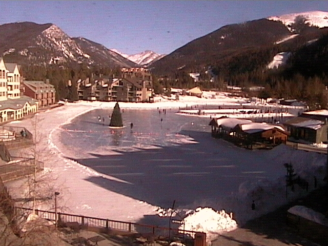
Lakeside Village
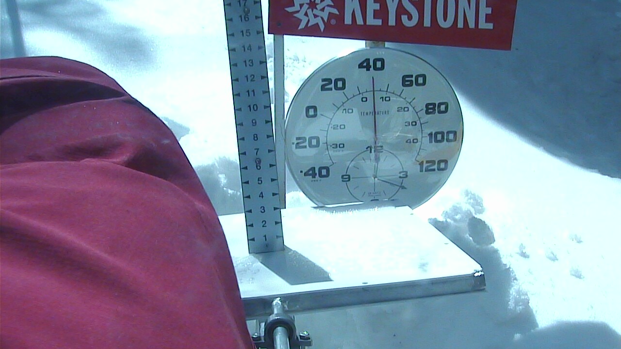
Snow Stake - 11,237 feet
THURSDAY
Jul 3

64° / 41°

7 - 15
mph
 0
0
FRIDAY
Jul 4

57° / 46°

9 - 17
mph
0
SATURDAY
Jul 5

61° / 48°
11 - 20
mph
0
SUNDAY
Jul 6
62° / 50°
6 - 14
mph
0
MONDAY
Jul 7
64° / 51°
6 - 14
mph
0
TUESDAY
Jul 8
66° / 51°
8 - 16
mph
0
WEDNESDAY
Jul 9
66° / 53°
9 - 17
mph
0
Mostly cloudy becoming partly cloudy at times continuing through overnight, with periods of rain developing in the afternoon through evening.
No snow.
Potential Precip:
0.03 to 0.17
Hi: 73°Low: 44°
13,989 feet to 16502 feet
Winds variable at 7 to 15 mph in the morning, becoming variable at 5 to 13 mph in the afternoon, and then NW at 6 to 14 mph overnight.
Mostly cloudy becoming partly cloudy at times continuing through overnight.
Light snow through the day and into the evening. Snowfall is forecast to be a trace amount during the day, and a trace amount in the evening.
Potential Precip:
0.03 to 0.17
Hi: 50°Low: 34°
13,989 feet to 16502 feet
Winds variable at 7 to 15 mph in the morning, becoming NW at 8 to 16 mph in the afternoon, and then NW at 14 to 25 mph overnight.
Partly cloudy becoming clear at times continuing through overnight. Periods of rain are expected in the morning.
No snow.
Potential Precip:
0.02 to 0.1
Hi: 66°Low: 48°
14,420 feet to 15257 feet
Winds NW at 9 to 17 mph in the morning, becoming variable at 4 to 11 mph in the afternoon, and then variable at 3 to 11 mph overnight.
Partly cloudy becoming clear at times continuing through overnight.
Scattered snow showers possible.
Potential Precip:
0.02 to 0.1
Hi: 43°Low: 37°
14,420 feet to 15257 feet
Winds W at 14 to 25 mph in the morning, becoming W at 18 to 29 mph in the afternoon, and then W at 12 to 23 mph overnight.
Partly cloudy becoming clear at times continuing through overnight.
No snow.
Potential Precip:
0 to 0.01
Hi: 69°Low: 50°
14,862 feet to 15970 feet
Winds W at 13 to 22 mph in the morning, becoming variable at 4 to 11 mph in the afternoon through overnight.
Partly cloudy becoming clear at times continuing through overnight.
No snow.
Potential Precip:
0 to 0.01
Hi: 47°Low: 39°
14,862 feet to 15970 feet
Winds W at 20 to 31 mph in the morning, becoming NW at 20 to 31 mph in the afternoon, and then W at 10 to 19 mph overnight.
Mostly cloudy becoming mostly clear at times continuing through overnight. Periods of rain are expected in the afternoon.
No snow.
Potential Precip:
0 to 0.02
Hi: 70°Low: 50°
15,299 feet to 15992 feet
Winds variable at 5 to 13 mph in the morning, becoming variable at 4 to 12 mph in the afternoon, and then variable at 5 to 13 mph overnight.
Mostly cloudy becoming mostly clear at times continuing through overnight. Periods of rain are expected in the afternoon.
No snow.
Potential Precip:
0 to 0.02
Hi: 47°Low: 43°
15,299 feet to 15992 feet
Winds NW at 13 to 22 mph in the morning, becoming SW at 10 to 19 mph in the afternoon, and then W at 11 to 20 mph overnight.
Partly cloudy becoming clear at times and then mostly clear overnight.
No snow.
Potential Precip:
0 to 0.01
Hi: 72°Low: 52°
15,618 feet to 16324 feet
Winds variable at 4 to 12 mph through the day, becoming variable at 5 to 12 mph overnight.
Partly cloudy becoming clear at times and then mostly clear overnight.
No snow.
Potential Precip:
0 to 0.01
Hi: 49°Low: 44°
15,618 feet to 16324 feet
Winds NW at 12 to 21 mph through the day, becoming W at 7 to 15 mph overnight.
Partly cloudy through the day and overnight, with periods of rain expected in the morning through afternoon.
No snow.
Potential Precip:
0.02 to 0.09
Hi: 74°Low: 52°
15,544 feet to 16658 feet
Winds variable at 5 to 13 mph through the day, becoming variable at 4 to 12 mph overnight.
Partly cloudy through the day and overnight, with periods of rain expected in the morning through afternoon.
No snow.
Potential Precip:
0.02 to 0.09
Hi: 51°Low: 42°
15,544 feet to 16658 feet
Winds variable at 10 to 19 mph through the day, becoming NW at 13 to 22 mph with gusts to 28 overnight.
Mostly cloudy becoming partly cloudy in the late morning continuing through overnight, with periods of rain expected in the afternoon.
No snow.
Potential Precip:
0 to 0.01
Hi: 75°Low: 54°
15,885 feet to 16808 feet
Winds variable at 6 to 14 mph through the day, becoming variable at 4 to 12 mph overnight.
Mostly cloudy becoming partly cloudy in the late morning continuing through overnight, with periods of rain expected in the afternoon.
No snow.
Potential Precip:
0 to 0.01
Hi: 51°Low: 46°
15,885 feet to 16808 feet
Winds variable at 9 to 18 mph through the day, becoming W at 10 to 19 mph overnight.
 Sunrise & Sunset

Lunar Calendar


 Snow Maps and Weather Stations in the Area
 ![]() 13in, past 6 days. Snow surface is packed powder and machine groomed
13in, past 6 days. Snow surface is packed powder and machine groomed
Snow report provided by SnoCountry
Plan your future trip using our temperature, snowfall, snow depth, and precipitation tool
 Day |
 High Temperatures |
 Low Temperatures |
 Precipitation |
 Snowfall |
 Snow Depth |
||||||||||||||
|---|---|---|---|---|---|---|---|---|---|---|---|---|---|---|---|---|---|---|---|
| Avg | High | Year | Low | Year | Avg | High | Year | Low | Year | Avg | Max | Year | Avg | Max | Year | Avg | Max | Year | |
| 1 | 69 | 78 | 1893 | 59 | 1895 | 36 | 49 | 1898 | 27 | 1908 | 0.060 | 0.88 | 1899 | T | T | 1951 | 0.0 | 0 | 2015 |
| 2 | 68 | 84 | 1893 | 53 | 1911 | 37 | 49 | 1910 | 30 | 1912 | 0.042 | 0.78 | 1911 | T | T | 2008 | 0.0 | 0 | 2015 |
| 3 | 66 | 76 | 1907 | 45 | 1897 | 37 | 49 | 1977 | 30 | 1910 | 0.047 | 1.00 | 1909 | 0.05 | 3.3 | 1897 | 0.0 | T | 1998 |
| 4 | 69 | 82 | 1898 | 51 | 1912 | 36 | 46 | 1895 | 28 | 1903 | 0.076 | 1.25 | 2006 | 0.08 | 5.3 | 1902 | 0.0 | 0 | 2015 |
| 5 | 69 | 78 | 1978 | 58 | 1894 | 36 | 47 | 1898 | 26 | 1902 | 0.064 | 1.42 | 1911 | 0.02 | 1.0 | 1993 | 0.0 | 0 | 2015 |
| 6 | 70 | 81 | 1978 | 58 | 1906 | 36 | 43 | 1896 | 27 | 1902 | 0.046 | 0.45 | 1911 | T | T | 1998 | 0.0 | T | 1998 |
| 7 | 70 | 81 | 1895 | 55 | 1906 | 36 | 50 | 1896 | 27 | 1902 | 0.077 | 0.78 | 1980 | T | T | 1952 | 0.0 | 0 | 2015 |
| 8 | 69 | 80 | 1901 | 52 | 1895 | 37 | 47 | 1901 | 28 | 1902 | 0.088 | 0.58 | 2015 | 0.00 | 0.1 | 1894 | 0.0 | 0 | 2015 |
| 9 | 70 | 82 | 1901 | 48 | 1895 | 36 | 43 | 1896 | 26 | 1902 | 0.076 | 0.42 | 1907 | 0.00 | 0.0 | 2015 | 0.0 | 0 | 2015 |
| 10 | 70 | 75 | 1977 | 56 | 1895 | 36 | 44 | 1899 | 26 | 1902 | 0.065 | 0.61 | 1896 | 0.00 | 0.0 | 2015 | 0.0 | 0 | 2015 |
| 11 | 71 | 82 | 1894 | 50 | 1895 | 37 | 45 | 1898 | 28 | 1902 | 0.062 | 0.68 | 1989 | T | T | 1953 | 0.0 | 0 | 2015 |
| 12 | 71 | 82 | 1901 | 58 | 1895 | 36 | 51 | 1896 | 22 | 1909 | 0.068 | 0.78 | 2011 | 0.00 | 0.0 | 2015 | 0.0 | 0 | 2015 |
| 13 | 70 | 79 | 1901 | 56 | 1895 | 37 | 47 | 1896 | 30 | 1895 | 0.075 | 0.85 | 1973 | T | T | 1954 | 0.0 | 0 | 2015 |
| 14 | 71 | 83 | 1978 | 54 | 1897 | 39 | 46 | 1912 | 30 | 1902 | 0.065 | 0.53 | 1907 | 0.00 | 0.0 | 2015 | 0.0 | 0 | 2015 |
| 15 | 72 | 83 | 1902 | 60 | 1899 | 38 | 45 | 1903 | 23 | 1907 | 0.053 | 0.42 | 1999 | T | T | 1894 | 0.0 | 0 | 2015 |
| 16 | 71 | 84 | 1901 | 55 | 1894 | 37 | 51 | 1896 | 20 | 1907 | 0.106 | 1.10 | 1947 | 0.00 | 0.0 | 2015 | 0.0 | 0 | 2015 |
| 17 | 71 | 82 | 1901 | 58 | 1896 | 37 | 48 | 1896 | 25 | 1907 | 0.075 | 0.78 | 2004 | 0.00 | 0.0 | 2015 | 0.0 | 0 | 2015 |
| 18 | 71 | 83 | 1901 | 57 | 1902 | 38 | 48 | 1977 | 26 | 1907 | 0.084 | 0.55 | 1962 | T | T | 1949 | 0.0 | 0 | 2015 |
| 19 | 69 | 84 | 1901 | 40 | 1897 | 36 | 51 | 1896 | 25 | 1907 | 0.128 | 3.17 | 2011 | T | T | 1949 | 0.0 | 0 | 2015 |
| 20 | 70 | 85 | 1901 | 54 | 1977 | 36 | 56 | 1896 | 27 | 1897 | 0.074 | 1.29 | 2007 | 0.00 | 0.0 | 2015 | 0.0 | 0 | 2015 |
| 21 | 72 | 84 | 1901 | 62 | 1977 | 37 | 51 | 1896 | 24 | 1907 | 0.102 | 1.82 | 1974 | 0.00 | 0.0 | 2015 | 0.0 | 0 | 2015 |
| 22 | 71 | 86 | 1901 | 58 | 1894 | 38 | 50 | 1977 | 30 | 1905 | 0.079 | 0.63 | 1986 | T | T | 1951 | 0.0 | 0 | 2015 |
| 23 | 70 | 85 | 1901 | 58 | 1897 | 39 | 52 | 1977 | 32 | 1905 | 0.089 | 1.32 | 1967 | T | T | 1951 | 0.0 | 0 | 2015 |
| 24 | 71 | 84 | 1901 | 59 | 1900 | 39 | 48 | 1977 | 29 | 1895 | 0.095 | 0.67 | 1977 | 0.00 | 0.0 | 2015 | 0.0 | 0 | 2015 |
| 25 | 72 | 84 | 1978 | 52 | 1896 | 38 | 48 | 1978 | 30 | 1900 | 0.071 | 0.51 | 1893 | T | T | 1894 | 0.0 | 0 | 2015 |
| 26 | 72 | 85 | 1895 | 60 | 1896 | 39 | 48 | 1907 | 34 | 1911 | 0.077 | 0.61 | 2006 | 0.00 | 0.0 | 2015 | 0.0 | 0 | 2015 |
| 27 | 72 | 85 | 1978 | 56 | 1912 | 41 | 48 | 1895 | 32 | 1911 | 0.076 | 0.50 | 1957 | 0.00 | 0.0 | 2015 | 0.0 | 0 | 2015 |
| 28 | 71 | 78 | 1897 | 60 | 1896 | 37 | 49 | 1896 | 23 | 1909 | 0.070 | 1.21 | 2012 | 0.00 | 0.0 | 2015 | 0.0 | 0 | 2015 |
| 29 | 71 | 79 | 1978 | 64 | 1910 | 39 | 58 | 1895 | 31 | 1894 | 0.115 | 1.13 | 2010 | T | T | 1951 | 0.0 | 0 | 2015 |
| 30 | 71 | 80 | 1901 | 58 | 1893 | 38 | 55 | 1896 | 30 | 1894 | 0.078 | 0.65 | 2009 | T | T | 1951 | 0.0 | 0 | 2015 |
| 31 | 73 | 83 | 1902 | 60 | 1894 | 39 | 51 | 1896 | 28 | 1911 | 0.137 | 2.05 | 1965 | 0.00 | 0.0 | 2015 | 0.0 | 0 | 2015 |
Day |
High Temperatures |
Low Temperatures |
Precipitation |
Snowfall |
Snow Depth |
||||||||||||||
|---|---|---|---|---|---|---|---|---|---|---|---|---|---|---|---|---|---|---|---|
| Avg | High | Year | Low | Year | Avg | High | Year | Low | Year | Avg | Max | Year | Avg | Max | Year | Avg | Max | Year | |
| 1 | 64 | 74 | 1998 | 44 | 2004 | 37 | 48 | 2012 | 30 | 2004 | 0.060 | 0.76 | 1966 | 0.00 | 0.0 | 2015 | 0.0 | 0 | 2015 |
| 2 | 65 | 74 | 2007 | 44 | 1995 | 39 | 48 | 1999 | 26 | 1995 | 0.030 | 0.30 | 1981 | 0.00 | 0.0 | 2015 | 0.0 | 0 | 2015 |
| 3 | 66 | 79 | 2003 | 51 | 1995 | 39 | 46 | 2001 | 26 | 1995 | 0.029 | 0.39 | 2006 | 0.03 | 2.0 | 1995 | 0.0 | 2 | 1995 |
| 4 | 66 | 78 | 2012 | 44 | 1995 | 39 | 46 | 1996 | 25 | 1993 | 0.057 | 0.83 | 1894 | 0.03 | 2.3 | 1993 | 0.0 | 2 | 1993 |
| 5 | 65 | 76 | 1992 | 43 | 1995 | 38 | 46 | 2015 | 23 | 1993 | 0.039 | 0.37 | 1993 | 0.04 | 2.7 | 1993 | 0.0 | 3 | 1993 |
| 6 | 65 | 77 | 1981 | 44 | 2009 | 39 | 50 | 1989 | 27 | 1982 | 0.056 | 0.59 | 1986 | 0.00 | 0.0 | 2015 | 0.0 | 0 | 2015 |
| 7 | 65 | 85 | 1981 | 53 | 1960 | 39 | 50 | 1989 | 19 | 1995 | 0.065 | 0.65 | 1954 | T | T | 1954 | 0.0 | 0 | 2015 |
| 8 | 64 | 76 | 1989 | 49 | 1992 | 39 | 48 | 1989 | 27 | 1994 | 0.067 | 0.45 | 2011 | T | T | 1993 | 0.0 | T | 1993 |
| 9 | 64 | 78 | 1966 | 50 | 2015 | 38 | 46 | 1989 | 27 | 2003 | 0.099 | 1.16 | 1973 | 0.04 | 3.0 | 1895 | 0.0 | 0 | 2015 |
| 10 | 64 | 75 | 1989 | 42 | 1895 | 39 | 49 | 1958 | 25 | 1895 | 0.086 | 1.01 | 1984 | 0.09 | 6.0 | 1895 | 0.0 | 0 | 2015 |
| 11 | 64 | 73 | 2002 | 38 | 1895 | 38 | 44 | 2009 | 25 | 1895 | 0.046 | 0.50 | 1998 | 0.02 | 1.0 | 1895 | 0.0 | 0 | 2015 |
| 12 | 64 | 76 | 1980 | 42 | 1895 | 38 | 47 | 2013 | 25 | 1895 | 0.100 | 0.91 | 2011 | 0.02 | 1.0 | 1895 | 0.0 | 0 | 2015 |
| 13 | 65 | 77 | 2002 | 38 | 1895 | 38 | 48 | 2013 | 20 | 1975 | 0.065 | 0.54 | 1973 | T | T | 1895 | 0.0 | 0 | 2015 |
| 14 | 65 | 76 | 2004 | 38 | 1895 | 39 | 46 | 2003 | 20 | 1895 | 0.055 | 0.39 | 1973 | T | T | 1953 | 0.0 | 0 | 2015 |
| 15 | 65 | 77 | 2004 | 52 | 1995 | 39 | 48 | 2003 | 29 | 1994 | 0.054 | 0.33 | 2015 | 0.00 | 0.2 | 1953 | 0.0 | 0 | 2015 |
| 16 | 66 | 77 | 2002 | 53 | 1973 | 39 | 46 | 2006 | 24 | 1994 | 0.075 | 1.04 | 2013 | 0.00 | 0.0 | 2015 | 0.0 | 0 | 2015 |
| 17 | 66 | 79 | 2002 | 53 | 1973 | 39 | 50 | 2005 | 22 | 1976 | 0.099 | 1.00 | 2004 | T | T | 1974 | 0.0 | 0 | 2015 |
| 18 | 66 | 76 | 2003 | 55 | 1987 | 40 | 52 | 1998 | 28 | 1976 | 0.092 | 0.92 | 1957 | 0.00 | 0.1 | 1953 | 0.0 | 0 | 2015 |
| 19 | 65 | 78 | 1998 | 55 | 1973 | 39 | 50 | 1998 | 32 | 1992 | 0.067 | 0.54 | 1973 | T | T | 1895 | 0.0 | 0 | 2015 |
| 20 | 65 | 75 | 2003 | 52 | 1957 | 39 | 46 | 2014 | 31 | 1995 | 0.086 | 1.07 | 1951 | T | T | 1961 | 0.0 | 0 | 2015 |
| 21 | 65 | 78 | 2012 | 51 | 1961 | 39 | 51 | 2005 | 31 | 1994 | 0.122 | 1.13 | 1985 | 0.03 | 2.0 | 1961 | 0.0 | 0 | 2015 |
| 22 | 65 | 79 | 2005 | 52 | 1895 | 40 | 50 | 2005 | 29 | 1961 | 0.088 | 1.00 | 1895 | 0.00 | 0.0 | 2015 | 0.0 | 0 | 2015 |
| 23 | 65 | 79 | 2005 | 48 | 1895 | 40 | 49 | 2005 | 28 | 1895 | 0.054 | 0.55 | 1957 | 0.00 | 0.0 | 2015 | 0.0 | 0 | 2015 |
| 24 | 65 | 76 | 1982 | 53 | 1986 | 40 | 54 | 2003 | 30 | 1995 | 0.109 | 0.99 | 1965 | T | T | 1955 | 0.0 | 0 | 2015 |
| 25 | 65 | 78 | 1980 | 54 | 1985 | 40 | 58 | 2003 | 29 | 1975 | 0.070 | 0.69 | 2015 | T | T | 1955 | 0.0 | 0 | 2015 |
| 26 | 64 | 74 | 1966 | 52 | 1955 | 40 | 47 | 1960 | 32 | 1993 | 0.103 | 0.73 | 1955 | T | T | 1953 | 0.0 | 0 | 2015 |
| 27 | 63 | 74 | 1978 | 54 | 1983 | 39 | 47 | 1960 | 29 | 1993 | 0.086 | 0.61 | 2003 | T | T | 1955 | 0.0 | 0 | 2015 |
| 28 | 65 | 79 | 1978 | 56 | 2004 | 40 | 51 | 1979 | 28 | 1993 | 0.089 | 1.00 | 1895 | 0.00 | 0.2 | 1953 | 0.0 | 0 | 2015 |
| 29 | 65 | 74 | 2006 | 50 | 2013 | 40 | 49 | 1979 | 28 | 1993 | 0.106 | 0.80 | 1998 | T | T | 1953 | 0.0 | 0 | 2015 |
| 30 | 65 | 74 | 2006 | 52 | 2014 | 40 | 47 | 2001 | 26 | 1971 | 0.095 | 0.67 | 1969 | T | T | 1961 | 0.0 | 0 | 2015 |
| 31 | 64 | 74 | 2006 | 51 | 2009 | 40 | 48 | 1966 | 26 | 1993 | 0.170 | 1.27 | 1961 | T | T | 1961 | 0.0 | 0 | 2015 |
 Mountain Base


