 Mt Waterman Mountain Hig... Mt Baldy Alta Sierra...
 Mont Ripley
  Houghton County Memorial Airport, MI Updated Jul 29 @ 09:12
 Northeast
 WebCams
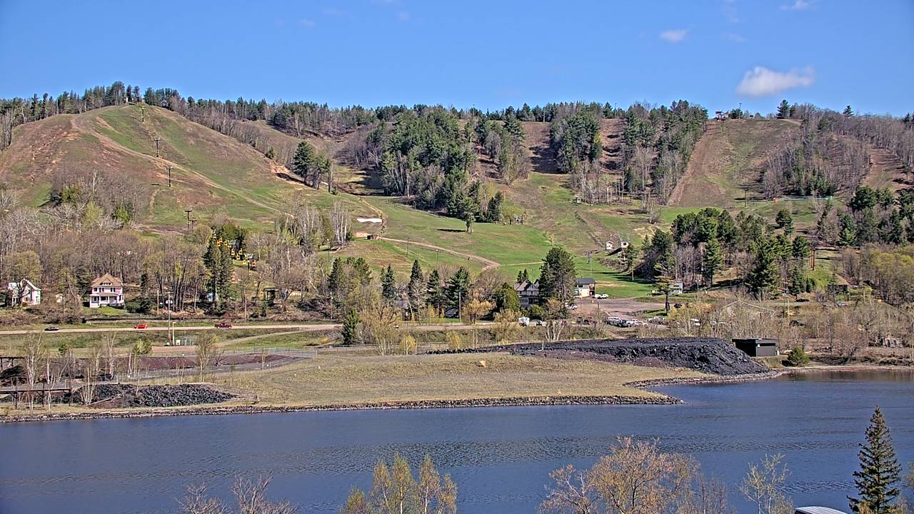
Ripley Cam—Still Image
Ripley Cam—Motion
WEDNESDAY
Jul 29

29° / 16°

10 - 19
mph
 6
6
THURSDAY
Jul 30

15° / 8°
10 - 18
mph
2
FRIDAY
Jul 31
29° / 12°

8 - 16
mph
1
SATURDAY
Aug 1

39° / 10°

14 - 23
mph
0
SUNDAY
Aug 2
11° / 2°
12 - 21
mph
1
MONDAY
Aug 3
6° / 1°
8 - 16
mph
0
TUESDAY
Aug 4
28° / 11°
15 - 26
mph
0
Cloudy through the day and overnight, with periods of snow expected at any time.
Moderate snow with periods of heavy during the day, becoming light in the evening and moderate overnight. Snowfall is forecast to be 4 to 6 during the day, and 2 to 4 inches in the evening and overnight.
Potential Precip:
0.15 to 0.76
Hi: 29°Low: 16°
0 feet to 0 feet
Winds S at 11 to 20 mph with gusts to 34 in the morning, becoming W at 10 to 19 mph with gusts to 28 in the afternoon, and then NW at 11 to 20 mph with gusts to 31 overnight.
Mostly cloudy becoming cloudy overnight continuing through overnight, with periods of snow expected in the morning through evening.
Light snow throughout the day and evening with periods of light during the day. Snowfall is forecast to be 1 to 2 during the day, and a trace amount in the evening.
Potential Precip:
0.03 to 0.15
Hi: 15°Low: 8°
0 feet to 0 feet
Winds NW at 11 to 20 mph in the morning, becoming W at 10 to 18 mph in the afternoon, and then variable at 5 to 13 mph with gusts to 19 overnight.
Partly cloudy becoming cloudy in the late morning and then partly cloudy overnight. Periods of snow are expected in the morning through evening.
Light snow throughout the day and evening with periods of moderate in the evening. Snowfall is forecast to be a trace amount during the day, and 1 to 2 in the evening.
Potential Precip:
0.02 to 0.09
Hi: 29°Low: 12°
0 feet to 4132 feet
Winds SW at 7 to 15 mph in the morning, becoming SW at 8 to 16 mph in the afternoon, and then SW at 10 to 18 mph with gusts to 34 overnight.
Mostly clear becoming mostly cloudy at times and then partly cloudy overnight. Periods of snow are expected in the evening through overnight.
Periods of light snow throughout the day and overnight. Snowfall is forecast to be a trace amount.
Potential Precip:
0 to 0.02
Hi: 39°Low: 10°
0 feet to 5279 feet
Winds SW at 10 to 18 mph with gusts to 32 in the morning, becoming W at 14 to 23 mph with gusts to 42 in the afternoon, and then NW at 15 to 26 mph with gusts to 47 overnight.
Mostly cloudy becoming cloudy in the late morning and then mostly cloudy overnight. Periods of snow are expected in the morning through evening.
Periods of light to moderate snow throughout the day. Snowfall is forecast to be 1 to 2 inches.
Potential Precip:
0.02 to 0.1
Hi: 11°Low: 2°
0 feet to 0 feet
Winds NW at 12 to 21 mph through the day, becoming N at 13 to 24 mph overnight.
Mostly cloudy becoming mostly clear at times continuing through overnight. Periods of snow are expected in the morning through afternoon.
Periods of light snow throughout the day. Snowfall is forecast to be a trace amount.
Potential Precip:
0 to 0.02
Hi: 6°Low: 1°
0 feet to 0 feet
Winds NW at 8 to 16 mph through the day, becoming S at 10 to 19 mph with gusts to 28 overnight.
Mostly clear becoming mostly cloudy in the afternoon continuing through overnight, with periods of snow developing in the evening through overnight.
Periods of light snow throughout the day and overnight. Snowfall is forecast to be a trace amount.
Potential Precip:
0.01 to 0.06
Hi: 28°Low: 11°
0 feet to 0 feet
Winds S at 15 to 26 mph with gusts to 34 through the day, becoming SW at 13 to 22 mph with gusts to 33 overnight.
 Sunrise & Sunset

Lunar Calendar


 Mid-Mountain
  Snow Maps and Weather Stations in the Area


