 Mt Waterman Mountain Hig... Mt Baldy Alta Sierra...
 Heavenly Mountain Resort
  US-50 Kahle Drive, NV Updated Jun 21 @ 11:09

 Northeast
 WebCams
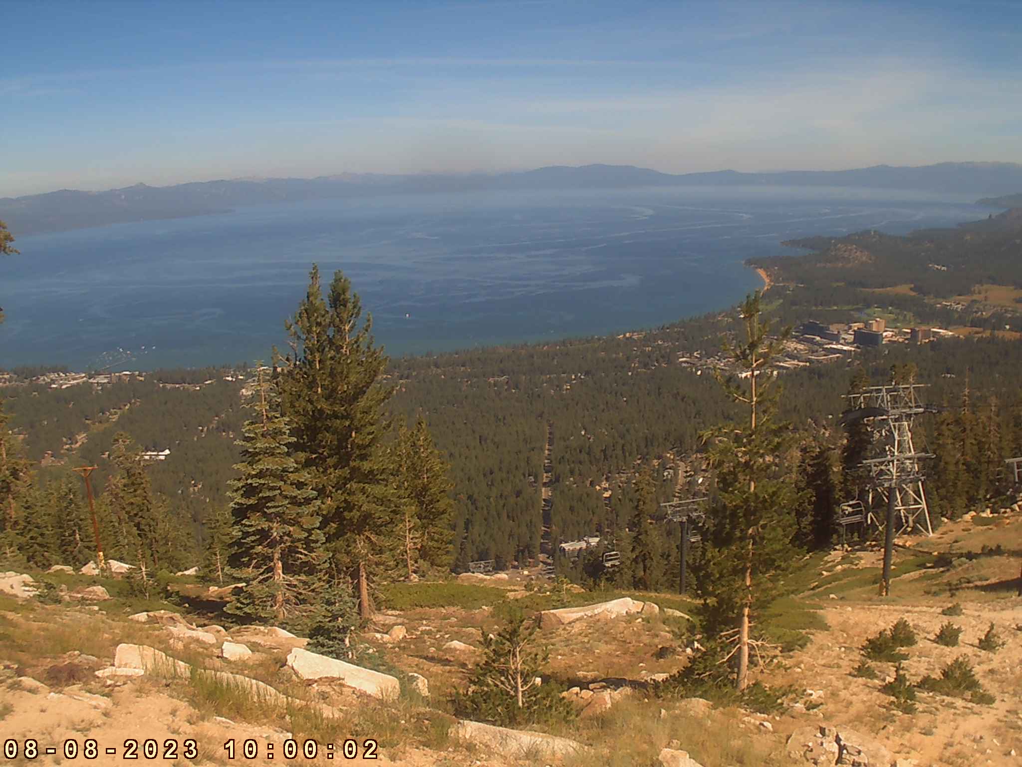
Heavenly Tram

Heavenly East Peak
SUNDAY
Jun 21

37° / 32°

49 - 60
mph
 4
4
MONDAY
Jun 22

39° / 32°

20 - 31
mph
0
TUESDAY
Jun 23
41° / 39°

7 - 15
mph
0
WEDNESDAY
Jun 24
42° / 36°
8 - 16
mph
0
THURSDAY
Jun 25
39° / 31°

23 - 34
mph
0
FRIDAY
Jun 26
32° / 23°
23 - 34
mph
3
SATURDAY
Jun 27
28° / 24°

16 - 27
mph
2
Partly cloudy becoming mostly cloudy in the late morning continuing through overnight, with periods of rain expected at any time.
No snow.
Potential Precip:
0.47 to 2.36
Hi: 45°Low: 43°
9,358 feet to 12210 feet
Winds SW at 33 to 44 mph with gusts to 68 in the morning, becoming SW at 13 to 24 mph with gusts to 38 in the afternoon, and then SW at 11 to 20 mph with gusts to 36 overnight.
Partly cloudy becoming mostly cloudy in the late morning continuing through overnight, with periods of snow expected at any time.
Heavy snow during the day, becoming light in the evening through overnight. Snowfall is forecast to be 4 to 7 during the day, and 1 to 2 inches in the evening and overnight.
Potential Precip:
0.47 to 2.36
Hi: 36°Low: 30°
9,358 feet to 12210 feet
Winds SW at 83 to 94 mph in the morning, becoming W at 55 to 66 mph in the afternoon, and then W at 41 to 52 mph overnight.
Mostly clear becoming partly cloudy at times continuing through overnight. Periods of rain are expected in the morning through afternoon.
No snow.
Potential Precip:
0.01 to 0.03
Hi: 48°Low: 40°
9,450 feet to 11803 feet
Winds SW at 8 to 16 mph in the morning, becoming SW at 6 to 14 mph in the afternoon, and then variable at 5 to 13 mph overnight.
Mostly clear becoming partly cloudy at times continuing through overnight. Periods of snow are expected in the morning through afternoon.
Periods of light snow during the day. Snowfall is forecast to be a trace amount during the day.
Potential Precip:
0.01 to 0.03
Hi: 37°Low: 30°
9,450 feet to 11803 feet
Winds W at 29 to 40 mph in the morning, becoming W at 25 to 36 mph in the afternoon, and then W at 18 to 29 mph overnight.
Partly cloudy through the day and overnight, with windy conditions at times.
No snow.
No precipitation expected.
Hi: 54°Low: 45°
11,679 feet to 11988 feet
Winds variable at 4 to 12 mph throughout the day and into overnight.
Partly cloudy through the day and overnight, with windy conditions at times.
No snow.
No precipitation expected.
Hi: 39°Low: 37°
11,679 feet to 11988 feet
Winds W at 10 to 19 mph in the morning, becoming W at 10 to 18 mph in the afternoon, and then W at 13 to 22 mph overnight.
Mostly clear becoming mostly cloudy in the afternoon and then partly cloudy overnight. Expect windy conditions at times.
No snow.
No precipitation expected.
Hi: 56°Low: 44°
10,609 feet to 11804 feet
Winds variable at 5 to 13 mph in the morning, becoming variable at 4 to 12 mph in the afternoon, and then variable at 5 to 13 mph overnight.
Mostly clear becoming mostly cloudy in the afternoon and then partly cloudy overnight. Expect windy conditions at times.
No snow.
No precipitation expected.
Hi: 39°Low: 33°
10,609 feet to 11804 feet
Winds SW at 10 to 19 mph in the morning, becoming SW at 10 to 18 mph in the afternoon, and then SW at 19 to 30 mph overnight.
Mostly cloudy becoming partly cloudy in the afternoon and then mostly cloudy overnight. Periods of rain are expected overnight.
No snow.
Potential Precip:
0 to 0.02
Hi: 55°Low: 42°
9,237 feet to 10805 feet
Winds SW at 8 to 16 mph through the day, becoming SW at 7 to 15 mph with gusts to 27 overnight.
Mostly cloudy becoming partly cloudy in the afternoon and then mostly cloudy overnight. Periods of snow are expected overnight.
Periods of light snow overnight. Snowfall is forecast to be a trace amount.
Potential Precip:
0 to 0.02
Hi: 36°Low: 29°
9,237 feet to 10805 feet
Winds SW at 26 to 37 mph through the day, becoming SW at 32 to 43 mph overnight.
Partly cloudy becoming mostly clear at times continuing through overnight, with periods of rain and snow expected overnight.
Periods of light snow throughout the day. Snowfall is forecast to be 1 to 2 inches.
Potential Precip:
0.09 to 0.44
Hi: 48°Low: 34°
6,852 feet to 9302 feet
Winds W at 11 to 20 mph with gusts to 30 through the day, becoming variable at 5 to 12 mph overnight.
Partly cloudy becoming mostly clear at times continuing through overnight, with periods of snow expected in the morning through afternoon.
Periods of moderate to heavy snow throughout the day. Snowfall is forecast to be 3 to 5 inches.
Potential Precip:
0.09 to 0.44
Hi: 29°Low: 21°
6,852 feet to 9302 feet
Winds SW at 26 to 37 mph through the day, becoming variable at 10 to 18 mph with gusts to 24 overnight.
Mostly cloudy becoming clear in the evening continuing through overnight.
Periods of light snow throughout the day. Snowfall is forecast to be a trace amount.
Potential Precip:
0.05 to 0.24
Hi: 41°Low: 35°
7,242 feet to 8179 feet
Winds variable at 7 to 15 mph through the day, becoming E at 9 to 17 mph with gusts to 25 overnight.
Mostly cloudy becoming clear in the evening continuing through overnight, with periods of snow expected in the morning through afternoon.
Periods of light to heavy snow throughout the day. Snowfall is forecast to be 2 to 3 inches.
Potential Precip:
0.05 to 0.24
Hi: 27°Low: 22°
7,242 feet to 8179 feet
Winds variable at 19 to 30 mph with gusts to 38 through the day, becoming variable at 37 to 48 mph overnight.
 Sunrise & Sunset

Lunar Calendar


 Snow Maps and Weather Stations in the Area
 ![]() 10in, past 3 days. Snow surface is packed powder and machine groomed
10in, past 3 days. Snow surface is packed powder and machine groomed
Snow report provided by SnoCountry
 Mountain Base


