 Mt Waterman Mt Baldy Mountain Hig... Snow Valley...
 Keystone Resort
  Granby-Grand County Airport, CO Updated Jul 27 @ 09:18

 North
North WebCams
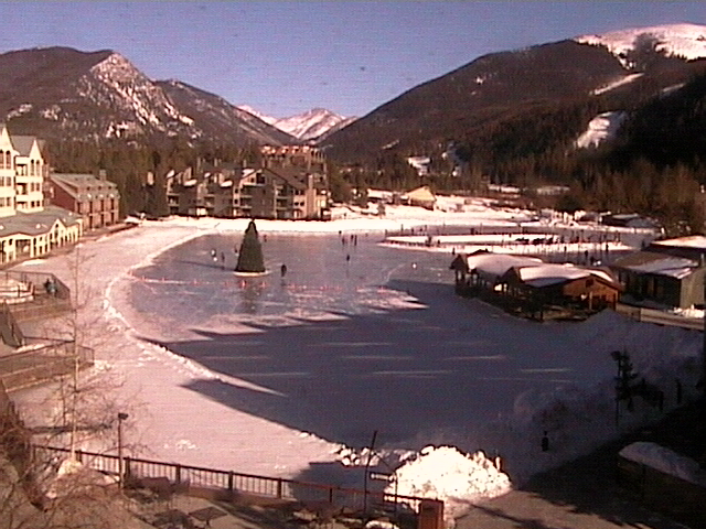
Lakeside Village
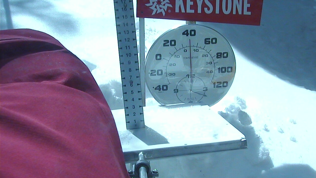
Snow Stake - 11,237 feet
MONDAY
Jul 27

35° / 28°

12 - 21
mph
 0
0
TUESDAY
Jul 28
31° / 21°

34 - 45
mph
2
WEDNESDAY
Jul 29

29° / 20°

6 - 14
mph
0
THURSDAY
Jul 30
32° / 24°
9 - 17
mph
0
FRIDAY
Jul 31

35° / 27°
4 - 12
mph
0
SATURDAY
Aug 1
37° / 33°
12 - 21
mph
0
SUNDAY
Aug 2

37° / 29°
12 - 21
mph
0
Mostly clear through the day becoming partly cloudy overnight. Periods of snow are expected in the evening through overnight.
Light snow in the evening through overnight. Snowfall is forecast to be a trace amount in the evening and overnight.
Potential Precip:
0.01 to 0.06
Hi: 43°Low: 29°
8,951 feet to 11632 feet
Winds W at 11 to 20 mph with gusts to 26 in the morning, becoming variable at 4 to 12 mph in the afternoon, and then W at 8 to 16 mph with gusts to 31 overnight.
Mostly clear through the day becoming partly cloudy overnight. Periods of snow are expected in the evening through overnight.
Light snow in the evening through overnight. Snowfall is forecast to be 1 to 2 inches in the evening and overnight.
Potential Precip:
0.01 to 0.06
Hi: 24°Low: 21°
8,951 feet to 11632 feet
Winds W at 45 to 56 mph with gusts to 70 in the morning, becoming W at 43 to 54 mph with gusts to 61 in the afternoon, and then W at 47 to 58 mph with gusts to 72 overnight.
Mostly clear becoming partly cloudy in the late morning continuing through overnight. Periods of rain and snow are expected overnight.
Light snow through the day and into overnight. Snowfall is forecast to be a trace amount during the day, and 1 to 2 inches in the evening and overnight.
Potential Precip:
0.05 to 0.25
Hi: 39°Low: 28°
8,026 feet to 10819 feet
Winds W at 17 to 28 mph with gusts to 36 in the morning, becoming W at 19 to 30 mph with gusts to 40 in the afternoon, and then W at 13 to 22 mph with gusts to 36 overnight.
Mostly clear becoming partly cloudy in the late morning continuing through overnight. Periods of snow are expected at any time.
Light snow during the day, becoming moderate in the evening through overnight. Snowfall is forecast to be 1 to 2 during the day, and 2 to 4 inches in the evening and overnight.
Potential Precip:
0.05 to 0.25
Hi: 19°Low: 10°
8,026 feet to 10819 feet
Winds W at 50 to 61 mph with gusts to 71 in the morning, becoming W at 58 to 69 mph in the afternoon, and then W at 43 to 54 mph with gusts to 65 overnight.
Mostly clear becoming clear in the late morning continuing through overnight.
Scattered snow showers possible.
Potential Precip:
0 to 0.01
Hi: 37°Low: 21°
6,112 feet to 10349 feet
Winds NW at 7 to 15 mph in the morning, becoming variable at 5 to 12 mph in the afternoon, and then variable at 5 to 13 mph overnight.
Mostly clear becoming clear in the late morning continuing through overnight.
Scattered snow showers possible.
Potential Precip:
0 to 0.01
Hi: 20°Low: 13°
6,112 feet to 10349 feet
Winds NW at 16 to 27 mph in the morning, becoming NW at 21 to 32 mph in the afternoon, and then NW at 31 to 42 mph with gusts to 59 overnight.
Clear through the day becoming mostly clear overnight. Expect windy conditions at times.
No snow.
No precipitation expected.
Hi: 40°Low: 25°
7,310 feet to 10960 feet
Winds NW at 9 to 17 mph in the morning, becoming variable at 5 to 12 mph in the afternoon, and then variable at 3 to 11 mph overnight.
Clear through the day becoming mostly clear overnight. Expect windy conditions at times.
No snow.
No precipitation expected.
Hi: 24°Low: 18°
7,310 feet to 10960 feet
Winds NW at 33 to 44 mph with gusts to 51 in the morning, becoming W at 32 to 43 mph with gusts to 49 in the afternoon through overnight.
Mostly cloudy becoming partly cloudy at times continuing through overnight, with windy conditions at times.
No snow.
No precipitation expected.
Hi: 42°Low: 29°
9,041 feet to 11482 feet
Winds variable at 5 to 12 mph through the day, becoming variable at 5 to 13 mph with gusts to 23 overnight.
Mostly cloudy becoming partly cloudy at times continuing through overnight, with windy conditions at times.
No snow.
No precipitation expected.
Hi: 23°Low: 20°
9,041 feet to 11482 feet
Winds W at 14 to 23 mph with gusts to 32 through the day, becoming W at 29 to 40 mph with gusts to 56 overnight.
Mostly cloudy becoming partly cloudy in the late morning continuing through overnight, with periods of snow developing in the afternoon through overnight.
Periods of light snow throughout the day and overnight. Snowfall is forecast to be a trace amount.
Potential Precip:
0 to 0.01
Hi: 45°Low: 37°
11,090 feet to 11945 feet
Winds variable at 6 to 14 mph with gusts to 20 through the day, becoming W at 7 to 15 mph with gusts to 24 overnight.
Mostly cloudy becoming partly cloudy in the late morning continuing through overnight, with periods of snow developing in the afternoon through overnight.
Periods of light snow throughout the day and overnight. Snowfall is forecast to be a trace amount.
Potential Precip:
0 to 0.01
Hi: 25°Low: 23°
11,090 feet to 11945 feet
Winds W at 24 to 35 mph with gusts to 45 through the day, becoming W at 36 to 47 mph with gusts to 58 overnight.
Mostly cloudy becoming cloudy at times continuing through overnight, with periods of snow expected in the afternoon.
Periods of light snow throughout the day. Snowfall is forecast to be a trace amount.
Potential Precip:
0 to 0.01
Hi: 44°Low: 34°
9,751 feet to 11846 feet
Winds variable at 8 to 16 mph with gusts to 24 through the day, becoming variable at 4 to 11 mph overnight.
Mostly cloudy becoming cloudy at times continuing through overnight, with periods of snow expected in the afternoon.
Periods of light snow throughout the day. Snowfall is forecast to be a trace amount.
Potential Precip:
0 to 0.01
Hi: 24°Low: 20°
9,751 feet to 11846 feet
Winds W at 24 to 35 mph through the day, becoming SW at 14 to 25 mph with gusts to 41 overnight.
 Sunrise & Sunset

Lunar Calendar


 Snow Maps and Weather Stations in the Area
 ![]() 13in, past 6 days. Snow surface is packed powder and machine groomed
13in, past 6 days. Snow surface is packed powder and machine groomed
Snow report provided by SnoCountry
Plan your future trip using our temperature, snowfall, snow depth, and precipitation tool
 Day |
 High Temperatures |
 Low Temperatures |
 Precipitation |
 Snowfall |
 Snow Depth |
||||||||||||||
|---|---|---|---|---|---|---|---|---|---|---|---|---|---|---|---|---|---|---|---|
| Avg | High | Year | Low | Year | Avg | High | Year | Low | Year | Avg | Max | Year | Avg | Max | Year | Avg | Max | Year | |
| 1 | 69 | 78 | 1893 | 59 | 1895 | 36 | 49 | 1898 | 27 | 1908 | 0.060 | 0.88 | 1899 | T | T | 1951 | 0.0 | 0 | 2015 |
| 2 | 68 | 84 | 1893 | 53 | 1911 | 37 | 49 | 1910 | 30 | 1912 | 0.042 | 0.78 | 1911 | T | T | 2008 | 0.0 | 0 | 2015 |
| 3 | 66 | 76 | 1907 | 45 | 1897 | 37 | 49 | 1977 | 30 | 1910 | 0.047 | 1.00 | 1909 | 0.05 | 3.3 | 1897 | 0.0 | T | 1998 |
| 4 | 69 | 82 | 1898 | 51 | 1912 | 36 | 46 | 1895 | 28 | 1903 | 0.076 | 1.25 | 2006 | 0.08 | 5.3 | 1902 | 0.0 | 0 | 2015 |
| 5 | 69 | 78 | 1978 | 58 | 1894 | 36 | 47 | 1898 | 26 | 1902 | 0.064 | 1.42 | 1911 | 0.02 | 1.0 | 1993 | 0.0 | 0 | 2015 |
| 6 | 70 | 81 | 1978 | 58 | 1906 | 36 | 43 | 1896 | 27 | 1902 | 0.046 | 0.45 | 1911 | T | T | 1998 | 0.0 | T | 1998 |
| 7 | 70 | 81 | 1895 | 55 | 1906 | 36 | 50 | 1896 | 27 | 1902 | 0.077 | 0.78 | 1980 | T | T | 1952 | 0.0 | 0 | 2015 |
| 8 | 69 | 80 | 1901 | 52 | 1895 | 37 | 47 | 1901 | 28 | 1902 | 0.088 | 0.58 | 2015 | 0.00 | 0.1 | 1894 | 0.0 | 0 | 2015 |
| 9 | 70 | 82 | 1901 | 48 | 1895 | 36 | 43 | 1896 | 26 | 1902 | 0.076 | 0.42 | 1907 | 0.00 | 0.0 | 2015 | 0.0 | 0 | 2015 |
| 10 | 70 | 75 | 1977 | 56 | 1895 | 36 | 44 | 1899 | 26 | 1902 | 0.065 | 0.61 | 1896 | 0.00 | 0.0 | 2015 | 0.0 | 0 | 2015 |
| 11 | 71 | 82 | 1894 | 50 | 1895 | 37 | 45 | 1898 | 28 | 1902 | 0.062 | 0.68 | 1989 | T | T | 1953 | 0.0 | 0 | 2015 |
| 12 | 71 | 82 | 1901 | 58 | 1895 | 36 | 51 | 1896 | 22 | 1909 | 0.068 | 0.78 | 2011 | 0.00 | 0.0 | 2015 | 0.0 | 0 | 2015 |
| 13 | 70 | 79 | 1901 | 56 | 1895 | 37 | 47 | 1896 | 30 | 1895 | 0.075 | 0.85 | 1973 | T | T | 1954 | 0.0 | 0 | 2015 |
| 14 | 71 | 83 | 1978 | 54 | 1897 | 39 | 46 | 1912 | 30 | 1902 | 0.065 | 0.53 | 1907 | 0.00 | 0.0 | 2015 | 0.0 | 0 | 2015 |
| 15 | 72 | 83 | 1902 | 60 | 1899 | 38 | 45 | 1903 | 23 | 1907 | 0.053 | 0.42 | 1999 | T | T | 1894 | 0.0 | 0 | 2015 |
| 16 | 71 | 84 | 1901 | 55 | 1894 | 37 | 51 | 1896 | 20 | 1907 | 0.106 | 1.10 | 1947 | 0.00 | 0.0 | 2015 | 0.0 | 0 | 2015 |
| 17 | 71 | 82 | 1901 | 58 | 1896 | 37 | 48 | 1896 | 25 | 1907 | 0.075 | 0.78 | 2004 | 0.00 | 0.0 | 2015 | 0.0 | 0 | 2015 |
| 18 | 71 | 83 | 1901 | 57 | 1902 | 38 | 48 | 1977 | 26 | 1907 | 0.084 | 0.55 | 1962 | T | T | 1949 | 0.0 | 0 | 2015 |
| 19 | 69 | 84 | 1901 | 40 | 1897 | 36 | 51 | 1896 | 25 | 1907 | 0.128 | 3.17 | 2011 | T | T | 1949 | 0.0 | 0 | 2015 |
| 20 | 70 | 85 | 1901 | 54 | 1977 | 36 | 56 | 1896 | 27 | 1897 | 0.074 | 1.29 | 2007 | 0.00 | 0.0 | 2015 | 0.0 | 0 | 2015 |
| 21 | 72 | 84 | 1901 | 62 | 1977 | 37 | 51 | 1896 | 24 | 1907 | 0.102 | 1.82 | 1974 | 0.00 | 0.0 | 2015 | 0.0 | 0 | 2015 |
| 22 | 71 | 86 | 1901 | 58 | 1894 | 38 | 50 | 1977 | 30 | 1905 | 0.079 | 0.63 | 1986 | T | T | 1951 | 0.0 | 0 | 2015 |
| 23 | 70 | 85 | 1901 | 58 | 1897 | 39 | 52 | 1977 | 32 | 1905 | 0.089 | 1.32 | 1967 | T | T | 1951 | 0.0 | 0 | 2015 |
| 24 | 71 | 84 | 1901 | 59 | 1900 | 39 | 48 | 1977 | 29 | 1895 | 0.095 | 0.67 | 1977 | 0.00 | 0.0 | 2015 | 0.0 | 0 | 2015 |
| 25 | 72 | 84 | 1978 | 52 | 1896 | 38 | 48 | 1978 | 30 | 1900 | 0.071 | 0.51 | 1893 | T | T | 1894 | 0.0 | 0 | 2015 |
| 26 | 72 | 85 | 1895 | 60 | 1896 | 39 | 48 | 1907 | 34 | 1911 | 0.077 | 0.61 | 2006 | 0.00 | 0.0 | 2015 | 0.0 | 0 | 2015 |
| 27 | 72 | 85 | 1978 | 56 | 1912 | 41 | 48 | 1895 | 32 | 1911 | 0.076 | 0.50 | 1957 | 0.00 | 0.0 | 2015 | 0.0 | 0 | 2015 |
| 28 | 71 | 78 | 1897 | 60 | 1896 | 37 | 49 | 1896 | 23 | 1909 | 0.070 | 1.21 | 2012 | 0.00 | 0.0 | 2015 | 0.0 | 0 | 2015 |
| 29 | 71 | 79 | 1978 | 64 | 1910 | 39 | 58 | 1895 | 31 | 1894 | 0.115 | 1.13 | 2010 | T | T | 1951 | 0.0 | 0 | 2015 |
| 30 | 71 | 80 | 1901 | 58 | 1893 | 38 | 55 | 1896 | 30 | 1894 | 0.078 | 0.65 | 2009 | T | T | 1951 | 0.0 | 0 | 2015 |
| 31 | 73 | 83 | 1902 | 60 | 1894 | 39 | 51 | 1896 | 28 | 1911 | 0.137 | 2.05 | 1965 | 0.00 | 0.0 | 2015 | 0.0 | 0 | 2015 |
Day |
High Temperatures |
Low Temperatures |
Precipitation |
Snowfall |
Snow Depth |
||||||||||||||
|---|---|---|---|---|---|---|---|---|---|---|---|---|---|---|---|---|---|---|---|
| Avg | High | Year | Low | Year | Avg | High | Year | Low | Year | Avg | Max | Year | Avg | Max | Year | Avg | Max | Year | |
| 1 | 64 | 74 | 1998 | 44 | 2004 | 37 | 48 | 2012 | 30 | 2004 | 0.060 | 0.76 | 1966 | 0.00 | 0.0 | 2015 | 0.0 | 0 | 2015 |
| 2 | 65 | 74 | 2007 | 44 | 1995 | 39 | 48 | 1999 | 26 | 1995 | 0.030 | 0.30 | 1981 | 0.00 | 0.0 | 2015 | 0.0 | 0 | 2015 |
| 3 | 66 | 79 | 2003 | 51 | 1995 | 39 | 46 | 2001 | 26 | 1995 | 0.029 | 0.39 | 2006 | 0.03 | 2.0 | 1995 | 0.0 | 2 | 1995 |
| 4 | 66 | 78 | 2012 | 44 | 1995 | 39 | 46 | 1996 | 25 | 1993 | 0.057 | 0.83 | 1894 | 0.03 | 2.3 | 1993 | 0.0 | 2 | 1993 |
| 5 | 65 | 76 | 1992 | 43 | 1995 | 38 | 46 | 2015 | 23 | 1993 | 0.039 | 0.37 | 1993 | 0.04 | 2.7 | 1993 | 0.0 | 3 | 1993 |
| 6 | 65 | 77 | 1981 | 44 | 2009 | 39 | 50 | 1989 | 27 | 1982 | 0.056 | 0.59 | 1986 | 0.00 | 0.0 | 2015 | 0.0 | 0 | 2015 |
| 7 | 65 | 85 | 1981 | 53 | 1960 | 39 | 50 | 1989 | 19 | 1995 | 0.065 | 0.65 | 1954 | T | T | 1954 | 0.0 | 0 | 2015 |
| 8 | 64 | 76 | 1989 | 49 | 1992 | 39 | 48 | 1989 | 27 | 1994 | 0.067 | 0.45 | 2011 | T | T | 1993 | 0.0 | T | 1993 |
| 9 | 64 | 78 | 1966 | 50 | 2015 | 38 | 46 | 1989 | 27 | 2003 | 0.099 | 1.16 | 1973 | 0.04 | 3.0 | 1895 | 0.0 | 0 | 2015 |
| 10 | 64 | 75 | 1989 | 42 | 1895 | 39 | 49 | 1958 | 25 | 1895 | 0.086 | 1.01 | 1984 | 0.09 | 6.0 | 1895 | 0.0 | 0 | 2015 |
| 11 | 64 | 73 | 2002 | 38 | 1895 | 38 | 44 | 2009 | 25 | 1895 | 0.046 | 0.50 | 1998 | 0.02 | 1.0 | 1895 | 0.0 | 0 | 2015 |
| 12 | 64 | 76 | 1980 | 42 | 1895 | 38 | 47 | 2013 | 25 | 1895 | 0.100 | 0.91 | 2011 | 0.02 | 1.0 | 1895 | 0.0 | 0 | 2015 |
| 13 | 65 | 77 | 2002 | 38 | 1895 | 38 | 48 | 2013 | 20 | 1975 | 0.065 | 0.54 | 1973 | T | T | 1895 | 0.0 | 0 | 2015 |
| 14 | 65 | 76 | 2004 | 38 | 1895 | 39 | 46 | 2003 | 20 | 1895 | 0.055 | 0.39 | 1973 | T | T | 1953 | 0.0 | 0 | 2015 |
| 15 | 65 | 77 | 2004 | 52 | 1995 | 39 | 48 | 2003 | 29 | 1994 | 0.054 | 0.33 | 2015 | 0.00 | 0.2 | 1953 | 0.0 | 0 | 2015 |
| 16 | 66 | 77 | 2002 | 53 | 1973 | 39 | 46 | 2006 | 24 | 1994 | 0.075 | 1.04 | 2013 | 0.00 | 0.0 | 2015 | 0.0 | 0 | 2015 |
| 17 | 66 | 79 | 2002 | 53 | 1973 | 39 | 50 | 2005 | 22 | 1976 | 0.099 | 1.00 | 2004 | T | T | 1974 | 0.0 | 0 | 2015 |
| 18 | 66 | 76 | 2003 | 55 | 1987 | 40 | 52 | 1998 | 28 | 1976 | 0.092 | 0.92 | 1957 | 0.00 | 0.1 | 1953 | 0.0 | 0 | 2015 |
| 19 | 65 | 78 | 1998 | 55 | 1973 | 39 | 50 | 1998 | 32 | 1992 | 0.067 | 0.54 | 1973 | T | T | 1895 | 0.0 | 0 | 2015 |
| 20 | 65 | 75 | 2003 | 52 | 1957 | 39 | 46 | 2014 | 31 | 1995 | 0.086 | 1.07 | 1951 | T | T | 1961 | 0.0 | 0 | 2015 |
| 21 | 65 | 78 | 2012 | 51 | 1961 | 39 | 51 | 2005 | 31 | 1994 | 0.122 | 1.13 | 1985 | 0.03 | 2.0 | 1961 | 0.0 | 0 | 2015 |
| 22 | 65 | 79 | 2005 | 52 | 1895 | 40 | 50 | 2005 | 29 | 1961 | 0.088 | 1.00 | 1895 | 0.00 | 0.0 | 2015 | 0.0 | 0 | 2015 |
| 23 | 65 | 79 | 2005 | 48 | 1895 | 40 | 49 | 2005 | 28 | 1895 | 0.054 | 0.55 | 1957 | 0.00 | 0.0 | 2015 | 0.0 | 0 | 2015 |
| 24 | 65 | 76 | 1982 | 53 | 1986 | 40 | 54 | 2003 | 30 | 1995 | 0.109 | 0.99 | 1965 | T | T | 1955 | 0.0 | 0 | 2015 |
| 25 | 65 | 78 | 1980 | 54 | 1985 | 40 | 58 | 2003 | 29 | 1975 | 0.070 | 0.69 | 2015 | T | T | 1955 | 0.0 | 0 | 2015 |
| 26 | 64 | 74 | 1966 | 52 | 1955 | 40 | 47 | 1960 | 32 | 1993 | 0.103 | 0.73 | 1955 | T | T | 1953 | 0.0 | 0 | 2015 |
| 27 | 63 | 74 | 1978 | 54 | 1983 | 39 | 47 | 1960 | 29 | 1993 | 0.086 | 0.61 | 2003 | T | T | 1955 | 0.0 | 0 | 2015 |
| 28 | 65 | 79 | 1978 | 56 | 2004 | 40 | 51 | 1979 | 28 | 1993 | 0.089 | 1.00 | 1895 | 0.00 | 0.2 | 1953 | 0.0 | 0 | 2015 |
| 29 | 65 | 74 | 2006 | 50 | 2013 | 40 | 49 | 1979 | 28 | 1993 | 0.106 | 0.80 | 1998 | T | T | 1953 | 0.0 | 0 | 2015 |
| 30 | 65 | 74 | 2006 | 52 | 2014 | 40 | 47 | 2001 | 26 | 1971 | 0.095 | 0.67 | 1969 | T | T | 1961 | 0.0 | 0 | 2015 |
| 31 | 64 | 74 | 2006 | 51 | 2009 | 40 | 48 | 1966 | 26 | 1993 | 0.170 | 1.27 | 1961 | T | T | 1961 | 0.0 | 0 | 2015 |
 Mountain Base


