 Indianhead M...
  Mt Waterman
  Mountain Hig... Mt Baldy
 Winter Park Resort
  Granby-Grand County Airport, CO Updated Jul 18 @ 05:15

 West
West WebCams

Winter Park Base Cam
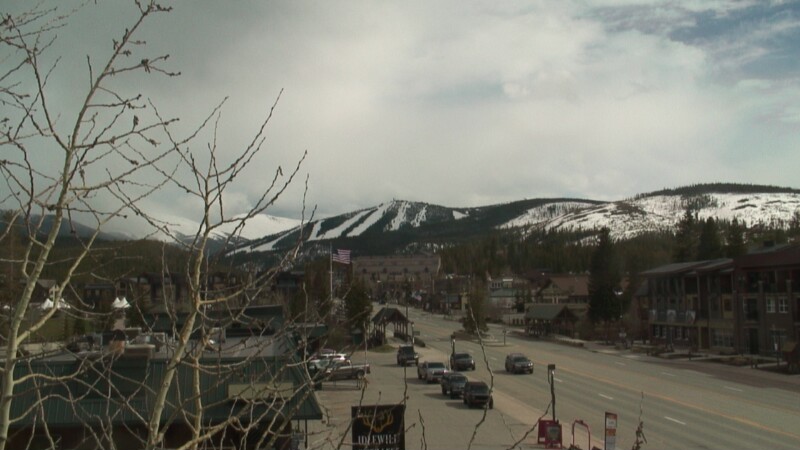
Winter Park Town cam
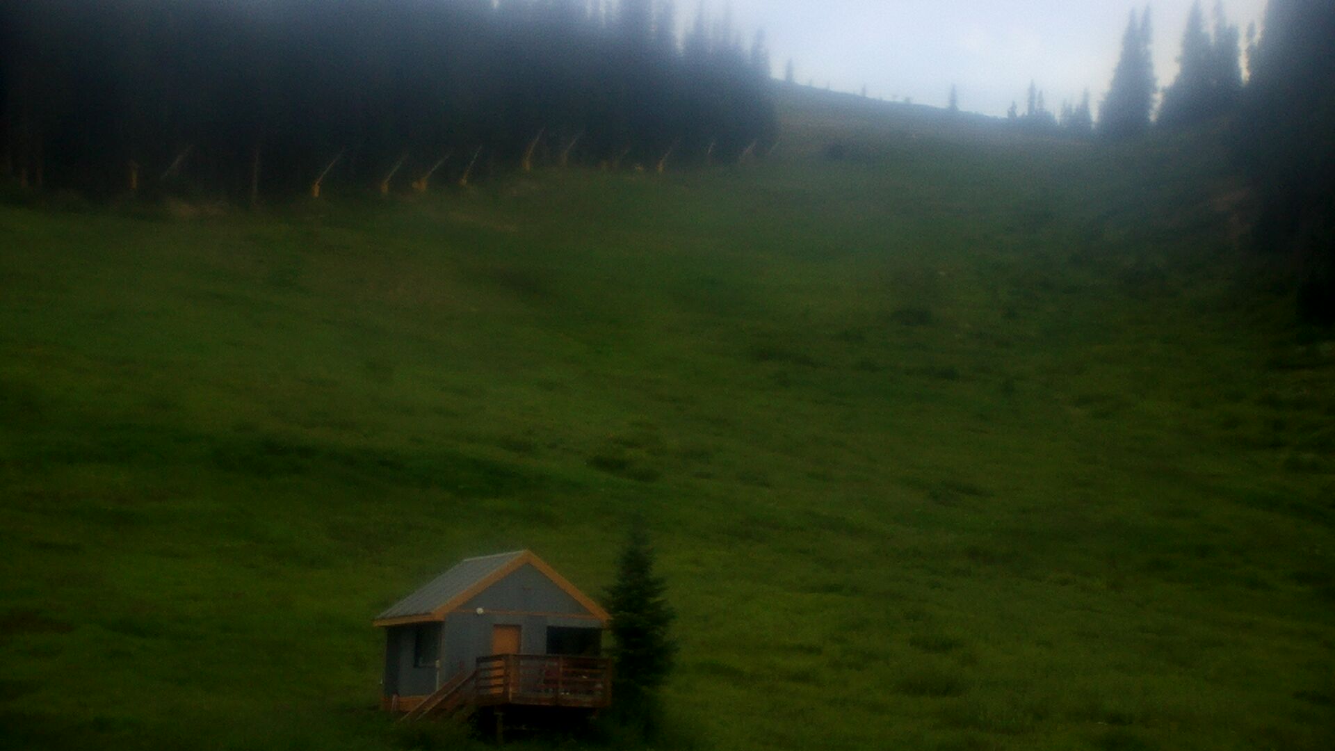
Snoasis

Sunspot
FRIDAY
Jul 18
59° / 50°

9 - 17
mph
 0
0
SATURDAY
Jul 19

63° / 51°

17 - 28
mph
0
SUNDAY
Jul 20
62° / 54°

7 - 15
mph
0
MONDAY
Jul 21
61° / 52°
9 - 17
mph
0
TUESDAY
Jul 22
63° / 54°
12 - 21
mph
0
WEDNESDAY
Jul 23
62° / 52°
11 - 20
mph
0
THURSDAY
Jul 24
65° / 54°
6 - 14
mph
0
Mostly clear through the day and overnight.
No snow.
Potential Precip:
0 to 0.02
Hi: 70°Low: 51°
14,870 feet to 15796 feet
Winds W at 8 to 16 mph in the morning, becoming variable at 5 to 13 mph in the afternoon, and then SW at 7 to 15 mph with gusts to 23 overnight.
Mostly clear through the day and overnight.
No snow.
Potential Precip:
0 to 0.02
Hi: 46°Low: 41°
14,870 feet to 15796 feet
Winds W at 15 to 26 mph through the day, becoming W at 20 to 31 mph overnight.
Partly cloudy through the day and overnight, with windy conditions at times.
No snow.
No precipitation expected.
Hi: 74°Low: 52°
14,833 feet to 16151 feet
Winds W at 16 to 27 mph in the morning, becoming W at 10 to 18 mph in the afternoon, and then variable at 5 to 13 mph overnight.
Partly cloudy through the day and overnight, with windy conditions at times.
No snow.
No precipitation expected.
Hi: 50°Low: 42°
14,833 feet to 16151 feet
Winds W at 18 to 29 mph in the morning, becoming NW at 16 to 27 mph in the afternoon, and then W at 13 to 24 mph overnight.
Partly cloudy through the day and overnight, with periods of rain expected in the morning through afternoon.
No snow.
Potential Precip:
0 to 0.02
Hi: 73°Low: 55°
15,340 feet to 15939 feet
Winds variable at 10 to 19 mph in the morning, becoming variable at 5 to 12 mph in the afternoon, and then SW at 6 to 14 mph overnight.
Partly cloudy through the day and overnight, with periods of rain expected in the morning through afternoon.
No snow.
Potential Precip:
0 to 0.02
Hi: 49°Low: 44°
15,340 feet to 15939 feet
Winds W at 10 to 19 mph in the morning, becoming W at 13 to 22 mph in the afternoon, and then W at 12 to 21 mph overnight.
Mostly cloudy becoming partly cloudy in the afternoon continuing through overnight, with periods of rain expected in the morning through afternoon.
No snow.
Potential Precip:
0.03 to 0.13
Hi: 72°Low: 53°
15,071 feet to 15799 feet
Winds variable at 13 to 22 mph in the morning, becoming SW at 6 to 14 mph in the afternoon, and then variable at 5 to 13 mph overnight.
Mostly cloudy becoming partly cloudy in the afternoon continuing through overnight, with periods of rain expected in the morning through afternoon.
No snow.
Potential Precip:
0.03 to 0.13
Hi: 48°Low: 42°
15,071 feet to 15799 feet
Winds W at 12 to 21 mph in the morning, becoming NW at 7 to 15 mph in the afternoon, and then W at 13 to 22 mph overnight.
Partly cloudy becoming mostly clear in the evening continuing through overnight, with periods of rain expected in the morning through afternoon.
No snow.
Potential Precip:
0 to 0.02
Hi: 75°Low: 54°
15,506 feet to 16233 feet
Winds variable at 11 to 20 mph through the day, becoming variable at 4 to 12 mph overnight.
Partly cloudy becoming mostly clear in the evening continuing through overnight, with periods of rain expected in the morning through afternoon.
No snow.
Potential Precip:
0 to 0.02
Hi: 51°Low: 45°
15,506 feet to 16233 feet
Winds variable at 10 to 19 mph through the day, becoming variable at 6 to 14 mph overnight.
Mostly cloudy becoming partly cloudy at times continuing through overnight. Periods of rain are expected in the morning through evening.
No snow.
Potential Precip:
0.12 to 0.6
Hi: 74°Low: 53°
15,530 feet to 16298 feet
Winds E at 9 to 17 mph through the day, becoming variable at 4 to 12 mph overnight.
Mostly cloudy becoming partly cloudy at times continuing through overnight. Periods of rain are expected in the morning through evening.
No snow.
Potential Precip:
0.12 to 0.6
Hi: 50°Low: 44°
15,530 feet to 16298 feet
Winds variable at 10 to 19 mph through the day, becoming NW at 9 to 18 mph overnight.
Partly cloudy becoming clear in the evening continuing through overnight.
No snow.
Potential Precip:
0.02 to 0.1
Hi: 77°Low: 54°
15,912 feet to 16481 feet
Winds variable at 6 to 14 mph through the day, becoming variable at 4 to 12 mph overnight.
Partly cloudy becoming clear in the evening continuing through overnight.
No snow.
Potential Precip:
0.02 to 0.1
Hi: 52°Low: 45°
15,912 feet to 16481 feet
Winds variable at 7 to 15 mph through the day, becoming W at 11 to 20 mph overnight.
 Sunrise & Sunset

Lunar Calendar


 Snow Maps and Weather Stations in the Area
 ![]() 22in, past 7 days. Snow surface is packed powder
22in, past 7 days. Snow surface is packed powder
Snow report provided by SnoCountry
Plan your future trip using our temperature, snowfall, snow depth, and precipitation tool
 Day |
 High Temperatures |
 Low Temperatures |
 Precipitation |
 Snowfall |
 Snow Depth |
||||||||||||||
|---|---|---|---|---|---|---|---|---|---|---|---|---|---|---|---|---|---|---|---|
| Avg | High | Year | Low | Year | Avg | High | Year | Low | Year | Avg | Max | Year | Avg | Max | Year | Avg | Max | Year | |
| 1 | 74 | 85 | 1975 | 65 | 1945 | 36 | 50 | 1947 | 30 | 1971 | 0.068 | 0.65 | 2004 | 0.00 | 0.0 | 2015 | 0.0 | 0 | 2015 |
| 2 | 75 | 86 | 1975 | 64 | 1945 | 36 | 50 | 1947 | 26 | 1945 | 0.026 | 0.62 | 2010 | 0.00 | 0.0 | 2015 | 0.0 | 0 | 2015 |
| 3 | 77 | 84 | 2002 | 69 | 1945 | 35 | 41 | 2003 | 28 | 1971 | 0.031 | 0.40 | 1981 | 0.00 | 0.0 | 2015 | 0.0 | 0 | 2015 |
| 4 | 76 | 84 | 1975 | 66 | 1943 | 35 | 50 | 1947 | 28 | 1945 | 0.048 | 0.61 | 1995 | 0.00 | 0.0 | 2015 | 0.0 | 0 | 2015 |
| 5 | 76 | 83 | 1975 | 68 | 1945 | 35 | 48 | 1947 | 24 | 1972 | 0.059 | 0.80 | 1993 | 0.00 | 0.0 | 2015 | 0.0 | 0 | 2015 |
| 6 | 75 | 82 | 2003 | 68 | 1946 | 35 | 52 | 1947 | 28 | 1971 | 0.068 | 0.86 | 2015 | 0.00 | 0.0 | 2015 | 0.0 | 0 | 2015 |
| 7 | 75 | 82 | 1971 | 70 | 1946 | 35 | 42 | 2002 | 28 | 1971 | 0.081 | 0.86 | 2012 | 0.00 | 0.0 | 2015 | 0.0 | 0 | 2015 |
| 8 | 75 | 81 | 2003 | 70 | 1970 | 37 | 50 | 1947 | 30 | 1972 | 0.078 | 0.89 | 1990 | 0.00 | 0.0 | 2015 | 0.0 | 0 | 2015 |
| 9 | 77 | 83 | 2003 | 70 | 1946 | 38 | 50 | 1947 | 31 | 1943 | 0.053 | 0.56 | 2012 | 0.00 | 0.0 | 2015 | 0.0 | 0 | 2015 |
| 10 | 75 | 82 | 2002 | 71 | 1972 | 37 | 51 | 1947 | 30 | 1972 | 0.061 | 0.70 | 1984 | 0.00 | 0.0 | 2015 | 0.0 | 0 | 2015 |
| 11 | 75 | 82 | 1971 | 68 | 1947 | 36 | 50 | 1947 | 30 | 1971 | 0.070 | 0.87 | 1953 | 0.00 | 0.0 | 2015 | 0.0 | 0 | 2015 |
| 12 | 76 | 85 | 1971 | 66 | 1945 | 36 | 50 | 1947 | 30 | 1975 | 0.053 | 0.64 | 1980 | 0.00 | 0.0 | 2015 | 0.0 | 0 | 2015 |
| 13 | 76 | 87 | 1971 | 66 | 1945 | 37 | 50 | 1947 | 30 | 1975 | 0.065 | 1.15 | 1957 | 0.00 | 0.0 | 2015 | 0.0 | 0 | 2015 |
| 14 | 77 | 86 | 1971 | 68 | 1945 | 36 | 41 | 2002 | 32 | 1972 | 0.078 | 0.93 | 2013 | 0.00 | 0.0 | 2015 | 0.0 | 0 | 2015 |
| 15 | 78 | 84 | 2003 | 71 | 1945 | 37 | 50 | 1947 | 32 | 1971 | 0.055 | 0.96 | 1975 | 0.00 | 0.0 | 2015 | 0.0 | 0 | 2015 |
| 16 | 77 | 83 | 1971 | 70 | 1944 | 37 | 52 | 1947 | 30 | 1970 | 0.040 | 0.50 | 1954 | 0.00 | 0.0 | 2015 | 0.0 | 0 | 2015 |
| 17 | 76 | 85 | 1971 | 66 | 1947 | 37 | 48 | 1947 | 30 | 1943 | 0.075 | 1.01 | 2012 | 0.00 | 0.0 | 2015 | 0.0 | 0 | 2015 |
| 18 | 77 | 87 | 1971 | 68 | 1947 | 38 | 50 | 1947 | 29 | 1943 | 0.059 | 0.58 | 1966 | 0.00 | 0.0 | 2015 | 0.0 | 0 | 2015 |
| 19 | 77 | 84 | 1970 | 68 | 1947 | 40 | 50 | 1947 | 30 | 1972 | 0.092 | 0.70 | 1985 | 0.00 | 0.0 | 2015 | 0.0 | 0 | 2015 |
| 20 | 77 | 84 | 2002 | 70 | 1971 | 39 | 46 | 2002 | 28 | 1971 | 0.119 | 1.85 | 1983 | 0.00 | 0.0 | 2015 | 0.0 | 0 | 2015 |
| 21 | 75 | 81 | 2003 | 70 | 1971 | 39 | 49 | 1947 | 30 | 1970 | 0.088 | 0.80 | 1985 | 0.00 | 0.0 | 2015 | 0.0 | 0 | 2015 |
| 22 | 76 | 84 | 2002 | 66 | 1947 | 37 | 50 | 1947 | 28 | 1944 | 0.046 | 0.40 | 1974 | 0.00 | 0.0 | 2015 | 0.0 | 0 | 2015 |
| 23 | 74 | 82 | 2003 | 67 | 1947 | 38 | 47 | 1947 | 28 | 1972 | 0.084 | 0.75 | 1974 | 0.00 | 0.0 | 2015 | 0.0 | 0 | 2015 |
| 24 | 75 | 82 | 1972 | 64 | 1947 | 39 | 49 | 1947 | 30 | 1971 | 0.077 | 0.56 | 1964 | 0.00 | 0.0 | 2015 | 0.0 | 0 | 2015 |
| 25 | 75 | 81 | 2003 | 64 | 1944 | 39 | 51 | 1947 | 31 | 1971 | 0.091 | 0.98 | 1965 | 0.00 | 0.0 | 2015 | 0.0 | 0 | 2015 |
| 26 | 74 | 78 | 1943 | 66 | 1944 | 37 | 50 | 1947 | 30 | 1975 | 0.104 | 1.35 | 1983 | 0.00 | 0.0 | 2015 | 0.0 | 0 | 2015 |
| 27 | 77 | 83 | 1943 | 72 | 1948 | 37 | 50 | 1947 | 28 | 1944 | 0.066 | 0.50 | 1972 | 0.00 | 0.0 | 2015 | 0.0 | 0 | 2015 |
| 28 | 76 | 81 | 1975 | 68 | 1944 | 37 | 48 | 1947 | 30 | 1972 | 0.040 | 0.49 | 1987 | 0.00 | 0.0 | 2015 | 0.0 | 0 | 2015 |
| 29 | 77 | 82 | 1975 | 73 | 1945 | 37 | 52 | 1947 | 28 | 1972 | 0.087 | 0.82 | 1989 | 0.00 | 0.0 | 2015 | 0.0 | 0 | 2015 |
| 30 | 76 | 82 | 1972 | 65 | 1948 | 37 | 51 | 1947 | 24 | 1971 | 0.126 | 1.20 | 1987 | 0.00 | 0.0 | 2015 | 0.0 | 0 | 2015 |
| 31 | 76 | 83 | 1972 | 70 | 1948 | 38 | 48 | 1947 | 25 | 1971 | 0.073 | 0.66 | 2014 | 0.00 | 0.0 | 2015 | 0.0 | 0 | 2015 |
Day |
High Temperatures |
Low Temperatures |
Precipitation |
Snowfall |
Snow Depth |
||||||||||||||
|---|---|---|---|---|---|---|---|---|---|---|---|---|---|---|---|---|---|---|---|
| Avg | High | Year | Low | Year | Avg | High | Year | Low | Year | Avg | Max | Year | Avg | Max | Year | Avg | Max | Year | |
| 1 | 62 | 71 | 1973 | 51 | 1968 | 38 | 49 | 1973 | 26 | 1968 | 0.059 | 0.50 | 1984 | 0.00 | 0.0 | 1984 | 1.3 | 25 | 1983 |
| 2 | 61 | 69 | 1973 | 56 | 1971 | 38 | 44 | 1981 | 31 | 1968 | 0.023 | 0.20 | 1980 | 0.00 | 0.0 | 1984 | 1.0 | 22 | 1983 |
| 3 | 62 | 70 | 1973 | 51 | 1981 | 38 | 47 | 1969 | 32 | 1965 | 0.031 | 0.56 | 1981 | 0.00 | 0.0 | 1984 | 0.9 | 19 | 1983 |
| 4 | 63 | 71 | 1964 | 50 | 1983 | 37 | 44 | 1973 | 26 | 1983 | 0.024 | 0.24 | 1979 | 0.00 | 0.0 | 1984 | 0.8 | 16 | 1983 |
| 5 | 63 | 71 | 1973 | 56 | 1983 | 38 | 48 | 1973 | 33 | 1983 | 0.063 | 0.38 | 1970 | 0.00 | 0.0 | 1984 | 0.6 | 12 | 1983 |
| 6 | 62 | 72 | 1973 | 48 | 1965 | 39 | 48 | 1973 | 28 | 1982 | 0.041 | 0.31 | 1968 | T | T | 1982 | 0.4 | 8 | 1983 |
| 7 | 63 | 76 | 1973 | 48 | 1965 | 39 | 45 | 1984 | 30 | 1982 | 0.028 | 0.20 | 1974 | 0.00 | 0.0 | 1984 | 0.1 | 3 | 1983 |
| 8 | 62 | 72 | 1964 | 48 | 1965 | 39 | 46 | 1966 | 34 | 1965 | 0.086 | 0.48 | 1981 | 0.00 | 0.0 | 1984 | 0.0 | T | 1983 |
| 9 | 61 | 71 | 1964 | 38 | 1965 | 39 | 44 | 1976 | 31 | 1965 | 0.090 | 0.42 | 1971 | 0.00 | 0.0 | 1984 | 0.0 | 0 | 1984 |
| 10 | 62 | 71 | 1964 | 46 | 1965 | 39 | 46 | 1966 | 31 | 1982 | 0.130 | 1.04 | 1981 | 0.00 | 0.0 | 1984 | 0.0 | 0 | 1984 |
| 11 | 62 | 70 | 1976 | 48 | 1965 | 39 | 44 | 1976 | 34 | 1975 | 0.034 | 0.24 | 1975 | 0.00 | 0.0 | 1984 | 0.0 | 0 | 1984 |
| 12 | 63 | 70 | 1976 | 45 | 1965 | 39 | 45 | 1973 | 32 | 1975 | 0.099 | 0.52 | 1980 | 0.00 | 0.0 | 1984 | 0.0 | 0 | 1984 |
| 13 | 62 | 70 | 1976 | 44 | 1965 | 39 | 46 | 1977 | 32 | 1965 | 0.044 | 0.25 | 1973 | 0.00 | 0.0 | 1984 | 0.0 | 0 | 1984 |
| 14 | 62 | 72 | 1971 | 47 | 1965 | 40 | 46 | 1971 | 32 | 1980 | 0.089 | 0.67 | 1973 | T | T | 1973 | 0.0 | T | 1973 |
| 15 | 62 | 70 | 1979 | 47 | 1973 | 40 | 46 | 1978 | 33 | 1980 | 0.052 | 0.36 | 1975 | 0.00 | 0.0 | 1984 | 0.0 | 0 | 1984 |
| 16 | 62 | 70 | 1971 | 50 | 1965 | 40 | 48 | 1969 | 34 | 1973 | 0.104 | 0.52 | 1975 | 0.00 | 0.0 | 1984 | 0.0 | 0 | 1984 |
| 17 | 64 | 70 | 1971 | 53 | 1973 | 40 | 46 | 1971 | 34 | 1975 | 0.105 | 0.54 | 1965 | 0.00 | 0.0 | 1984 | 0.0 | 0 | 1984 |
| 18 | 63 | 74 | 1971 | 53 | 1967 | 40 | 44 | 1977 | 36 | 1980 | 0.060 | 0.45 | 1966 | 0.00 | 0.0 | 1984 | 0.0 | 0 | 1984 |
| 19 | 61 | 67 | 1977 | 50 | 1973 | 40 | 43 | 1972 | 34 | 1979 | 0.115 | 0.63 | 1973 | 0.00 | 0.0 | 1984 | 0.0 | T | 1971 |
| 20 | 62 | 69 | 1964 | 49 | 1971 | 39 | 44 | 1964 | 34 | 1971 | 0.172 | 1.14 | 1983 | 0.00 | 0.0 | 1984 | 0.0 | 0 | 1984 |
| 21 | 61 | 70 | 1964 | 51 | 1976 | 40 | 45 | 1981 | 32 | 1973 | 0.079 | 0.37 | 1974 | T | T | 1973 | 0.0 | T | 1973 |
| 22 | 62 | 71 | 1964 | 52 | 1977 | 40 | 46 | 1982 | 30 | 1978 | 0.127 | 0.55 | 1965 | 0.00 | 0.0 | 1984 | 0.0 | 0 | 1984 |
| 23 | 62 | 68 | 1981 | 54 | 1965 | 40 | 48 | 1982 | 32 | 1973 | 0.136 | 1.19 | 1965 | 0.00 | 0.0 | 1984 | 0.0 | 0 | 1984 |
| 24 | 61 | 69 | 1981 | 49 | 1983 | 39 | 44 | 1972 | 34 | 1973 | 0.120 | 0.67 | 1965 | T | T | 1973 | 0.0 | T | 1973 |
| 25 | 60 | 68 | 1982 | 50 | 1965 | 39 | 42 | 1983 | 30 | 1973 | 0.065 | 0.46 | 1965 | T | T | 1973 | 0.0 | T | 1973 |
| 26 | 61 | 68 | 1969 | 50 | 1977 | 39 | 44 | 1978 | 32 | 1973 | 0.096 | 0.47 | 1965 | 0.00 | 0.0 | 1984 | 0.0 | 0 | 1984 |
| 27 | 61 | 72 | 1978 | 49 | 1965 | 39 | 43 | 1968 | 34 | 1981 | 0.073 | 0.48 | 1972 | 0.00 | 0.0 | 1984 | 0.0 | 0 | 1984 |
| 28 | 62 | 76 | 1978 | 53 | 1965 | 39 | 44 | 1978 | 33 | 1981 | 0.051 | 0.37 | 1965 | T | T | 1973 | 0.0 | T | 1973 |
| 29 | 63 | 73 | 1969 | 56 | 1983 | 39 | 46 | 1966 | 34 | 1973 | 0.069 | 0.70 | 1982 | 0.00 | 0.0 | 1984 | 0.0 | 0 | 1984 |
| 30 | 62 | 70 | 1967 | 46 | 1982 | 40 | 46 | 1981 | 30 | 1971 | 0.101 | 0.65 | 1973 | 0.00 | 0.0 | 1984 | 0.0 | 0 | 1984 |
| 31 | 62 | 72 | 1966 | 52 | 1973 | 39 | 46 | 1972 | 33 | 1973 | 0.080 | 0.66 | 1965 | 0.00 | 0.0 | 1984 | 0.0 | 0 | 1984 |
 Mountain Base


