 *An El Nino is still favored according to the above Climate Prediction Center chart*
 *We have seen some areas of cooling in the Nino 1+2 and 3 regions, as this El Nino struggles to form. This is indicating cooling in the subsurface waters, which is a factor that is looked at for potential SST's*
 *As of Sep 12, there is some warming going on again in the referenced "Nino 3" region, so overall there is a positive SST anomaly, but mostly less than +.5 (in yellow on the above chart), which is the threshold that needs to be met for 3 consecutive months before an actual El Nino pattern is recognized. For now we are in an "ENSO neutral" status.


HEAT: https://www.washingtonpost.com/news/capital-weather-gang/wp/2018/07/17/scorching-scandinavia-record-breaking-heat-hits-norway-finland-and-sweden (90+ degrees in Norway, all time record high temps!)
Great resource for current SST’s and anomalies:
https://www.tropicaltidbits.com/analysis/ocean/
International Research Institute:
https://iri.columbia.edu/our-expertise/climate/forecasts/enso/current/?enso_tab=enso-cpc_plume
Latest ENSO Discussion:
http://www.cpc.ncep.noaa.gov/products/analysis_monitoring/enso_advisory/ensodisc.php
Space Weather ("Solar Minimum"):
https://www.swpc.noaa.gov/products/solar-cycle-progression
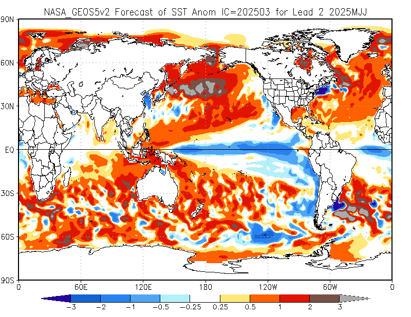
NCEP model forecast SST anomalies (1 model forecasting La Nina):
http://www.cpc.ncep.noaa.gov/products/NMME/current/tmpsfc_Seas2.html
The ONE outlier model forecasting La Nina:
http://www.cpc.ncep.noaa.gov/products/NMME/current/images/NASA_GEOS5v2_ensemble_tmpsfc_season2.png
Loads of the latest SST charts from ESRL, knock yourself out:
https://www.esrl.noaa.gov/psd/map/clim/sst.shtml
Best anomaly chart (in my opinion):
https://www.esrl.noaa.gov/psd/map/images/sst/sst.anom.hov.gif
Detailed ENSO Discussion from NOAA:
http://www.cpc.ncep.noaa.gov/products/analysis_monitoring/lanina/enso_evolution-status-fcsts-web.pdf
More info/ charts on Modoki El Nino:
http://www.jamstec.go.jp/frcgc/research/d1/iod/enmodoki_home_s.html.en
El Nino/ La Nina years/ ONI:
http://ggweather.com/enso/oni.htm
A GREAT resource for "no BS" historical ski season info:
http://bestsnow.net/
Latest PDO and history:
http://research.jisao.washington.edu/pdo/PDO.latest.txt


Forecast discussion for the Upper Midwest
Short Range- 0-6 days- (Following is written solely for N.MN and the UP of MI as they are likely the only areas left in the region that still have ski resorts open)
Pattern change from recent warmth to much cooler conditions has already taken place or it soon to do so. Mid week snows for the Arrowhead of MN- accumulations likely in the 2-5" range. Snow will melt, but not as fast as it should this time of year with temps below freezing at night and upper 30's until late in the weekend.
*An El Nino is still favored according to the above Climate Prediction Center chart**We have seen some areas of cooling in the Nino 1+2 and 3 regions, as this El Nino struggles to form. This is indicating cooling in the subsurface waters, which is a factor that is looked at for potential SST's**As of Sep 12, there is some warming going on again in the referenced "Nino 3" region, so overall there is a positive SST anomaly, but mostly less than +.5 (in yellow on the above chart), which is the threshold that needs to be met for 3 consecutive months before an actual El Nino pattern is recognized. For now we are in an "ENSO neutral" status.HEAT: https://www.washingtonpost.com/news/capital-weather-gang/wp/2018/07/17/scorching-scandinavia-record-breaking-heat-hits-norway-finland-and-sweden (90+ degrees in Norway, all time record high temps!)
Great resource for current SST’s and anomalies:
https://www.tropicaltidbits.com/analysis/ocean/
International Research Institute:
https://iri.columbia.edu/our-expertise/climate/forecasts/enso/current/?enso_tab=enso-cpc_plume
Latest ENSO Discussion:
http://www.cpc.ncep.noaa.gov/products/analysis_monitoring/enso_advisory/ensodisc.php
Space Weather ("Solar Minimum"):
https://www.swpc.noaa.gov/products/solar-cycle-progression
NCEP model forecast SST anomalies (1 model forecasting La Nina):
http://www.cpc.ncep.noaa.gov/products/NMME/current/tmpsfc_Seas2.html
The ONE outlier model forecasting La Nina:
http://www.cpc.ncep.noaa.gov/products/NMME/current/images/NASA_GEOS5v2_ensemble_tmpsfc_season2.png
Loads of the latest SST charts from ESRL, knock yourself out:
https://www.esrl.noaa.gov/psd/map/clim/sst.shtml
Best anomaly chart (in my opinion):
https://www.esrl.noaa.gov/psd/map/images/sst/sst.anom.hov.gif
Detailed ENSO Discussion from NOAA:
http://www.cpc.ncep.noaa.gov/products/analysis_monitoring/lanina/enso_evolution-status-fcsts-web.pdf
More info/ charts on Modoki El Nino:
http://www.jamstec.go.jp/frcgc/research/d1/iod/enmodoki_home_s.html.en
El Nino/ La Nina years/ ONI:
http://ggweather.com/enso/oni.htm
A GREAT resource for "no BS" historical ski season info:
http://bestsnow.net/
Latest PDO and history:
http://research.jisao.washington.edu/pdo/PDO.latest.txt


 48°
33°
48°
33°

 51°
42°
51°
42°
 39°
32°
39°
32°

 48°
33°
48°
33°


